
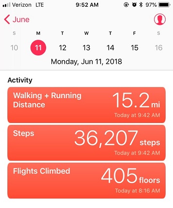
RT Length: 15.2 miles
Elevation Gain: 4596’
June 11, 2018: This hike has been on my bucket list ever since I discovered it’s the highest mountain on earth when measured from the sea floor. You see, Mountains are generally measured from sea level, in which case Mount Everest (29,028 feet; 8,848 meters) is king. Hawaii’s Mauna Kea, though, rises an astonishing 33,476 feet (10,203 meters) from the depths of the Pacific Ocean floor. Measuring from base to peak, Mauna Kea is the tallest mountain on earth.
We’re here in Hawaii on a family vacation, celebrating my son’s High School Graduation and enlistment in the United States Air Force. My mom and brother tried just about everything to get me not to hike this mountain. They hate that I hike alone, and kept coming up with excuses as to why I wouldn’t be able to go on a solo hike on this trip. (No, they didn’t want to hike with me). You see, we were so busy they just didn’t see how I could schedule it in. I told them I’d make it a sunrise hike (even though I hate those due to hiking in the dark and the cold), meaning I’d be back home no later than 10am, which wouldn’t interfere too much with our day. Well, maybe now we could find time on Tuesday or Wednesday (the only day snow was predicted on the mountain) as those were our late start days.
Then the volcano erupted and changed all our plans. My brother figured the eruption ensured I wouldn’t be able to hike, and let met me know the National Park was closed (our plan for Monday and Tuesday) thinking this would mean I couldn’t hike because the trail would be closed. Fortunately for me I knew Mauna Kea isn’t located anywhere near the National Park. I called the visitors center and Mauna Kea was open. Yes, I could hike all the way to the top, as the current eruption wasn’t interfering with Mauna Kea (although the areas usually erupt together). I saw this as my opportunity and took it! Since we could no longer visit the National Park on Monday I was going to hike while everyone else slept in.
I woke up at 1am. The wind was howling outside. My mom said that was reason enough not to hike because it had been rattling the windows all night and was sure to be intolerable on the summit, but Mountain Forecast said the winds were 5-10mph at the summit, so undeterred I drove to the Mauna Kea visitor’s center.
There were only about 6 spaces in the entire parking lot, with a lot of signage letting visitors know drones were not allowed in the area. When I got there I saw a couple of people in the parking lot with telescopes set up, pointing towards the stars. It was a very clear night, and since there are no big cities on the island of Hawaii and no bright lights to dampen the view the stargazing was phenomenal, even without a telescope.
The visitors’ center webpage (http://www.ifa.hawaii.edu/info/vis/visiting-mauna-kea/hiking.html) had a lot of information about hiking Mauna Kea. A lot of information!!! Most of it would be redundant to someone who regularly hikes 13ers and 14ers. I’d actually say it was overkill, but if you live in Hawaii or are a visiting hiker from sea level you probably could benefit from this information.
I was supposed to sign in at the trail register, but I couldn’t find it? I looked and looked and looked, but in the dark I just didn’t see a trail register. Oh well, my family knew where I was and when to expect me home. The visitors in the parking lot didn’t speak English, so we smiled at each other and I was on my way at 2:30am.
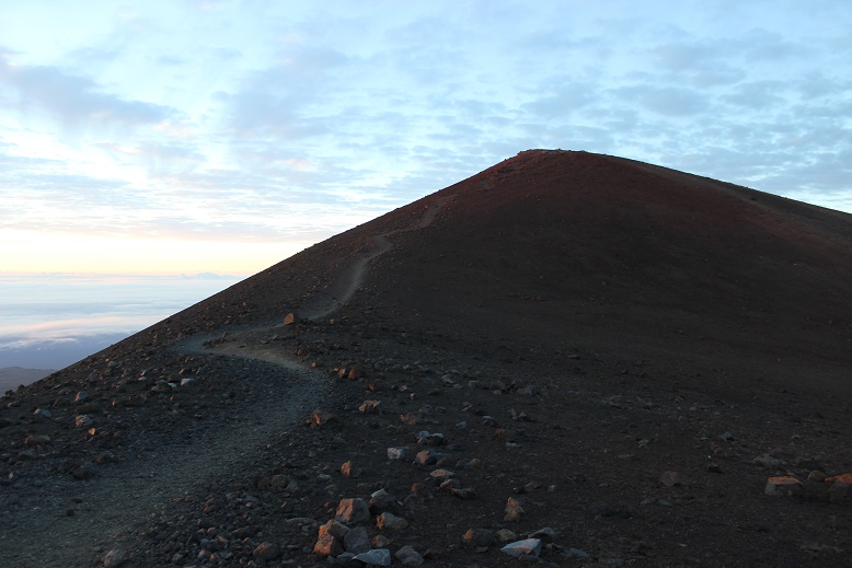
The trail actually starts about 1/10th of a mile up the road from the visitors center. I crossed the road and followed a 4WD trail to the left. The entire trail is located above treeline. It starts at 9200’, but since it’s actually a volcano very little grows on this mountain. I followed an old 4WD trail in the dark that led me to a station set up for me to clean off my shoes. I did so. This was the true start of the trail.

I looked for a trail register here as well but didn’t see one. I hiked about half a mile and came upon another sign. This one was broken and missing most of the information. Just imagine seeing this sign in the dark! I wasn’t sure which way to go, as both right and left seemed like legitimate trails. Actually, they were, but one went up the mountain and the other went back and connected with another road. I took the path to the left (which ended up being the correct path: I fixed the sign on my way down).

From this point on the trail passed through several different zones of lava, all with varying degrees of rock-like ground cover. It started out as a very sandy beach-like scree

And slowly changed into small rocks, and then medium sized rocks, and then large rocks. The terrain kept changing and changing as I hiked. It was difficult to stay on the trail, as in the dark everything looked the same. There was no clear trail visible in the sand and gravel. On the way back in the light of day however a trail was clearly visible.
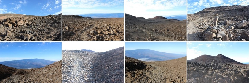
There were posts in the ground every 100 yards or so, indicating the trail. The posts let me know I was on track, but varied in where they were placed: sometimes they were in front of the trail, sometimes behind, sometimes to the left or the right. But as long as I was near a post I knew I was in relatively close proximity to the actual trail.
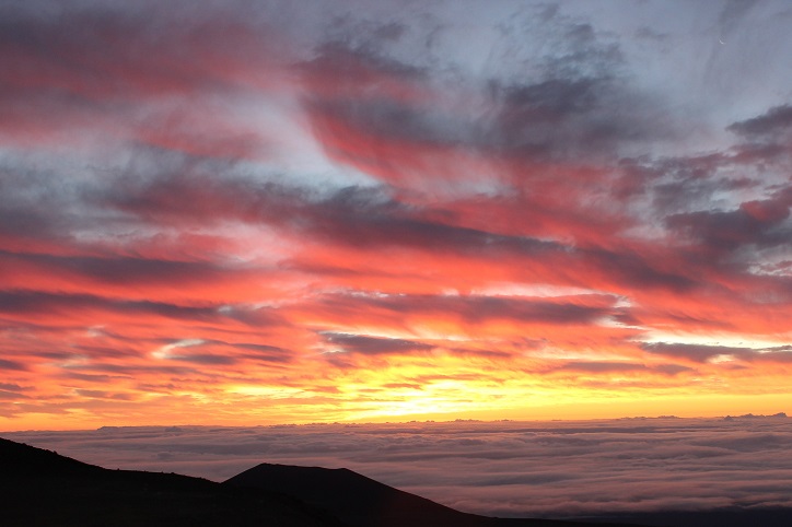
After hiking for about 2 miles I looked back and saw a glow in the distance. At first I thought I was looking at the town of Hilo, but that just didn’t make sense. Hilo should have been further north, and the lights reflecting off the low lying clouds looked more red than what should have been yellow street lights.
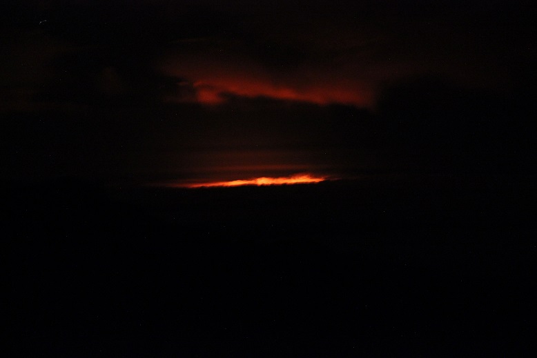
The further I hiked the more I kept stopping and looking behind me. Eventually it became clear I was looking at the glow of the volcanic eruption. Wow! What a sight to see! The horizon came into focus and I could see the red glow of the lava in the distance.

Did I mention it was cold? And windy! And really, really cold. And that wind!!! I’d brought my warm weather gear and North Face jacket with me on this trip, getting funny looks from employees at the Kona Airport as I wore it because it didn’t fit in my luggage. But I was praising myself for my foresight now. In fact, even with my snow gloves and knit hat I was shivering. I kept wanting to turn and look around at the lava glow but was too cold to stop and truly appreciate the view for any real length of time. My lips were frozen and my cheeks were numb. I wished it would warm up! I really didn’t like these sunrise summits: All this hiking in the dark and cold takes its toll on a hiker.
This hike seemed to go on and on and on with no clear gain in view. Everything looked the same in the dark: flat and still yet full of shadows. I was gaining in elevation, but it didn’t seem all that drastic. All I could think about as I trudged on was how wonderful it would be to have my family’s blessing and support on these hikes, instead of their constant fear and displeasure each time I go. I shouldn’t feel guilty every time I go on a hike. I’ve come to the realization I’m not going to change their views, so it’s something I’ll need to continue to enjoy for my own sake, and try my best to drown out their disappointment.
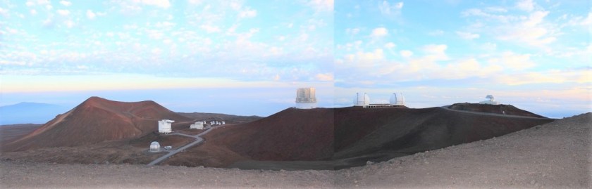
As the horizon started to lighten I saw the headlights from two cars come into view. There’s a paved road you can take to the summit (if you take a special tour and get a pass) that parallels the hiking trail for a bit. These groups must have been visitors on a sunrise tour.
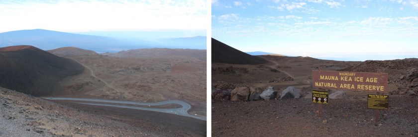
The end of the hike passes through the Mauna Kea Ice Age Natural Area Reserve, and then follows the paved road for the last mile to the summit.

This paved road also takes you to the Observatory.
This was the easiest part of the hike by far: hiking on a paved road is much easier than hiking on uneven gravel. It was my goal to make it to the summit before the sunrise, and it looked like I was pushing it. The trail map said it was 6 miles to the summit, but it had obviously been longer than that, and my timing was off for a sunrise summit.
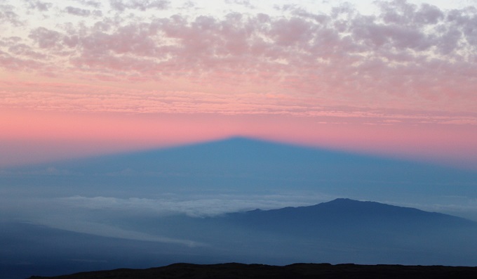
I looked to the left and could see a mountain in the morning light. This picture explains it all: the mountain in the middle is not a mountain at all, but the shadow of the volcano I was hiking, Mauna Kea, in the sunrise behind me.
The sun was rising so I quickened my pace and made it around the last curve. But it wasn’t the last of the hike. I still had a little ways to walk off the paved road to make it to the true summit. This was easy to navigate, only made difficult by the wind.
I summited at 5:30am, just as the sun was beginning to rise
There was a shrine at the summit. I respected the shrine by not standing on it or even touching it, even though it would have been extremely helpful in taking my summit photo.

This site has religious significance to the Hawaiian natives, including who’s allowed to stand on the summit so I tried to remain as respectful as possible.
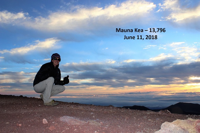
At this point I was above the clouds, looking east towards the ocean.
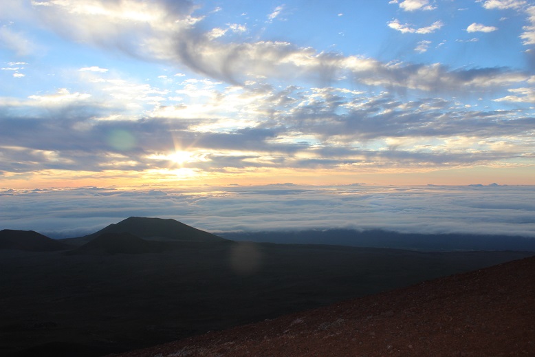
It was very, very cold and the winds were probably around 40mph, much faster than the 5-10mph predicted. I was completely numb, and headed back down quickly. There were two couples on the paved road looking at the summit, dressed in parkas and huddling together to keep warm. They were respecting the ancient rules and weren’t summiting today (you must start hiking at the bottom to stand on the summit).
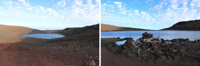
Here’s a good picture of where the trail starts back down at the junction of the paved road. If you look at the picture on the left, just as the trail ends it actually gives you the option of turning right and visiting an alpine lake.
This lake is named Lake Waiau, and sits at an elevation of 13,020’. This lake is also a sacred site. Waiau means “swirling water” in the Hawaiian language, and this phrase is probably meant to evoke the myth that Lake Waiau is the portal to the spirit world or underworld. In ancient times, the ali’i, Hawaiian royalty, would throw the umbilical cord of their first-born son into the lake to ensure their future success as a chief. When I visited the lake today I saw a shrine I expect was used for this purpose.
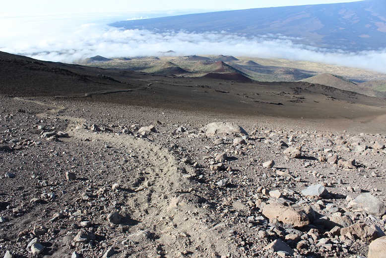
I turned around and descended through the varying degrees of decomposed lava. In the light of day the terrain looked like a moonscape, dry and barren with a large boulder thrown in here and there as if placed by an explosion.
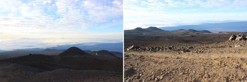
There were several calderas in view, and I thought once again of how Mauna Kea usually erupts simultaneously with Kilauea. There had also been numerous earthquakes on Mauna Kea in the past few days, so I crossed my fingers I’d make it safely off the mountain before another earthquake occurred (side note: several occurred during our stay, with the largest registering 5.4: another eruption is eminent).

I turned around and looked back at the summit, in the light of day clearly being able to see the paved path to the top.

I stopped here to take a quick video of the landscape
The final descent took much longer than I remembered it taking to hike up. It was much steeper hiking back down than I’d remembered as well. I could see the marine layer coming in from Hilo and the rest of my path down to the visitor’s center. If you look closely here, you can see there isn’t a shadow being cast by the sun, but different colors of lava from separate eruptions flowing into one area.
I fixed the broken sign and made it back to the visitors center at 8:30am, making this 15.2 mile trek of 4500+ feet in elevation gain in 6 hours. The website information page says most fit hikers complete the hike in 8 hours. I was feeling pretty good about myself!
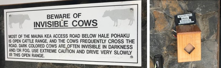
I came back here the next day for the stargazing, and talked with the rangers about their registration box. This was it, located as far from the parking lot as possible, adjacent to the front door around the back of the building. This doesn’t look like any hiker registration box I’ve ever seen, but for those of you intending to take this hike here’s what it looks like. It’s right below the “Beware of Invisible Cows” sign…
I’m glad I did everything possible to make this hike possible, even though my family wasn’t on board with the whole thing. It was truly worth the experience!

I always thought sea level was used as elevation and not sea bed floor because that is subject to change. I also understand your families deep concern for your safety and welfare. That’s called L O V E . I also believe you should follow your heart and your convictions,no matter who it may offend.It’s easy to see the desire you have from your writings to overcome and conquer great obstacles that most people try and avoid.When I return to some of your past writings ,I am assured that it was courage and determination that brought you safely thus far . Lest I should forget,I wish nothing but the best for your son as he enters basic training in July. I’m sure as a mother you will be there when he graduates.You have much to be proud of in the whole of your family.
LikeLike