Mt Princeton – 14,197 and Tigger Peak 13,280

image

Notes:

·
Snow starts at 12000’ and keeps going from
there.  Bring microspikes.  Snowshoes weren’t needed.  

·
I can see tons of potential avalanche danger on
this hike with more snow.  

·
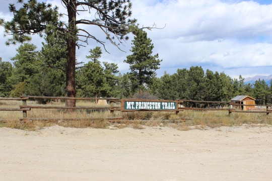
The lower Mt Princeton Road Trailhead is
actually pretty nice.

image

·
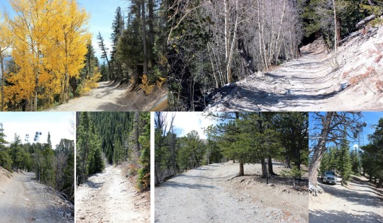
The road from here to the radio towers wasn’t as
bad as I’d been led to believe.  It was definitely
4WD, but it wasn’t that difficult.  The
only down side was it was narrow, so if you came across another vehicle it
would take a bit of maneuvering to get around each other.  I have a Tundra, so this was an issue for
me.  Two Jeeps wouldn’t have an
issue.  Side note:  the trail was dry when I took it.  If it was wet or had snow or ice it would
probably be much more technical to navigate.
I could see several dry gullies I’m assuming flow over the road when it
rains/snow melts.  

image

·
There are spots to park your vehicle at the
radio towers, but they aren’t obvious, and they’re tight.  I had ‘fun’ turning around my truck when I
discovered the road was one way in and out.
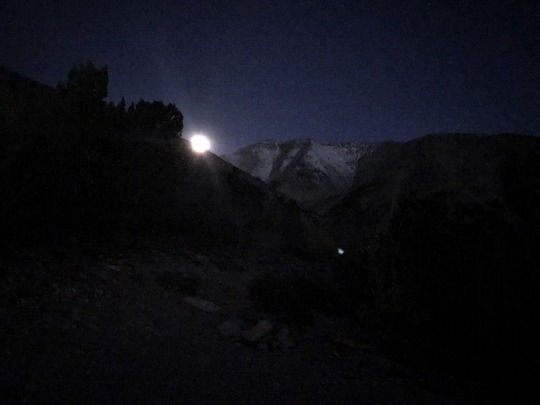
I began at 6am.  For
anyone wanting to know what it looks like hiking in the dark, here you go:

image

This was my first view of Mt Princeton

image

The trail after the towers begins on road 322A.  It can be difficult to find the towers in the
dark, but if you’ve driven 3 miles since the lower trailhead and come upon a
sharp curve, you’ve missed the towers.  

image

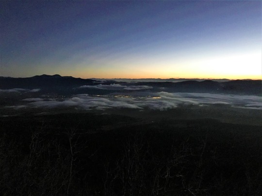
It was pretty cool to look back on Buena Vista and see it
covered in fog and haze

image

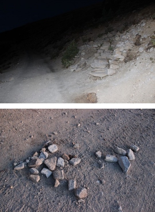
The first couple of miles follow the 4WD road up 322A.  Then the real trail starts up to the right of
the hillside.  There’s no sign, except
this wonderful, um, arrow of rocks? pointing the way.

image

As soon as you get up this small hill you get a great view
of Mt. Princeton.  

image

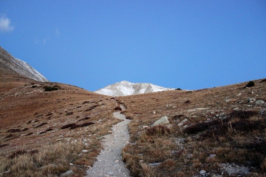
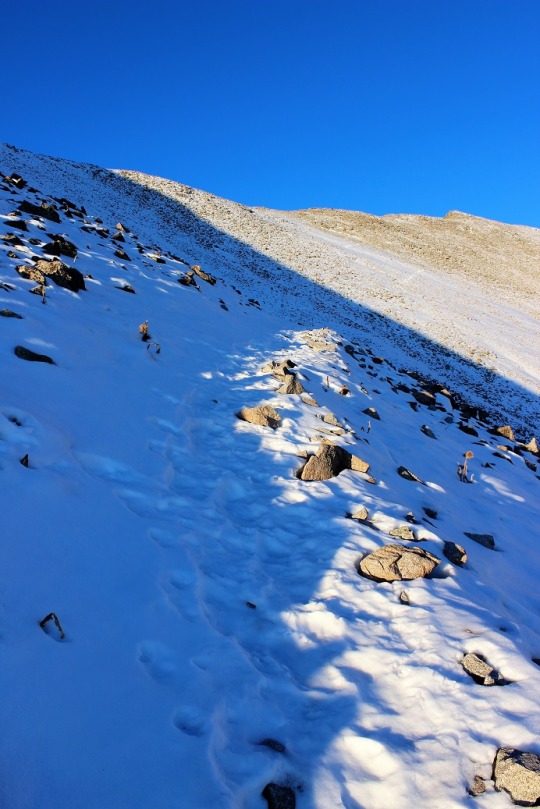
From here snow at minimum lined the trail for the rest of
the hike, and at most completely covered it.
I put on my microspikes and continued on.  

image
image
image

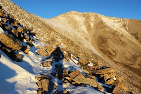
Shadowselfie, because I do that type of thing

image

At this point I was thinking it was probably a good thing I
had snow on the trail, since I was probably walking over a lot of scree.  I prefer snow to scree any day.

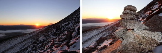
Oh, and when I turned back around I saw the SUNRISE!  Colorado 14er sunrises are AMAZING!!

image

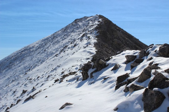
When I got to the top of the ridge I noticed a wind wall in
front of me and a mountain to my left.  I
got out my Peakbagger app, and discovered it was Tigger Peak (13,280).  It was only .3 miles away, so I made note of
the location to hike on the way back.

image

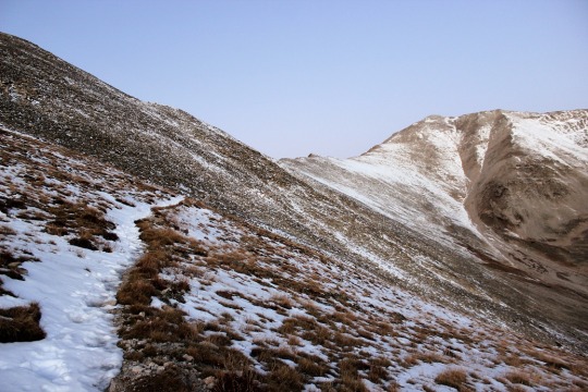
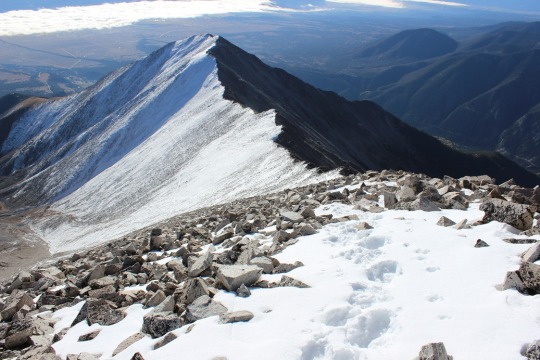
I turned right and got a good look at the rest of the hike
up Mt. Princeton.  From here it’s .7miles
to the top.  There was a pretty good
trail for most of the way, but when it was covered in snow I just followed the
ridge to the right.  

image

Some places had a lot of snow and I did a bit of post holing
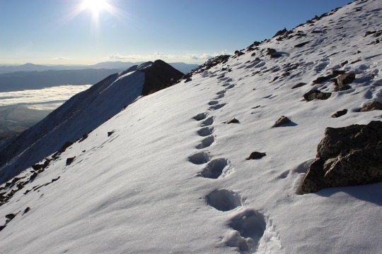
image
image

Others were bare

image

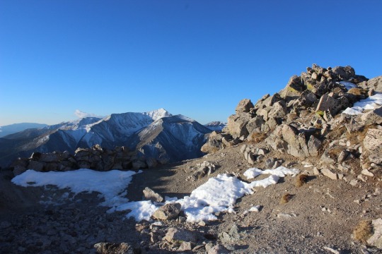
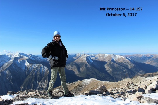
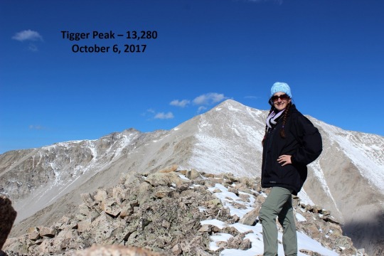
I summited to an absolutely beautiful view!  Here’s photo proof I summited:

image

The weather reports said 40 degrees with 25-30 MPH winds and
45MPH gusts, so I dressed warmly (multiple layers, hats, scarves, etc.)  Either I did an excellent job over dressing,
or it wasn’t that cold out.  I barely had
any wind for the entire hike, except on the exposed ridges.  

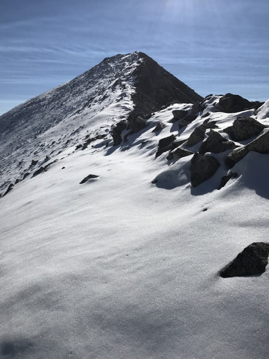
At this point I turned to head back down Mt Princeton’s
ridge. Take a look at Tigger Peak!  

image

It took a lot longer to hike down than I remembered hiking
up, but I had to be very careful of foot placement.  Despite microspikes it was still slippery.  I ended up tripping once and hitting my left
knee pretty hard.  I felt silly and
continued on.  

The trail to Tigger Peak had a ridge and what I considered a
false summit.  And due to the recent
snow, no trail.  Well, I’m assuming it’s
due to the recent snow.  It might not
have a trail at all anyway?  In any
event, there wasn’t a visible trial, so I got to make my own!  I considered this a very awesome opportunity,
and I was careful to make sure my steps were secure.  

image

On the ridge between the two small what I considered summits
of Tigger Peak it happened:

image

I was on a part of the route with exposed rock (no
snow).  I lifted my right foot to take a
step, and abruptly pirouetted and started falling towards the rocks.  You see, when I’d tripped earlier apparently
I’d tripped on broken microspikes:  One
of the hooks holding them together had come loose, and now, when I’d lifted my
foot, the hook on my left microspike attached to my right microspike, and I
fell down like that giant in Jack and the Beanstock with the tied
shoelaces.  It all happened in slow
motion.  In fact, I had time to curse
twice.  (Side note, I don’t actually
cuss, so I said “Gosh Darn It! Flibbity-gibbit” (seriously)).  

I’m not going to lie, it hurt.  But I didn’t sit there.  As soon as my knee hit the rock and I could, I
untangled myself, got up, and started hiking.
I could tell nothing was broken, but it stung badly.  The best way to fix this (I know from
experience) is to walk/hike it off.  So I
kept going, looking down at my knee every few seconds, expecting to see
blood.  Luckily that never happened.

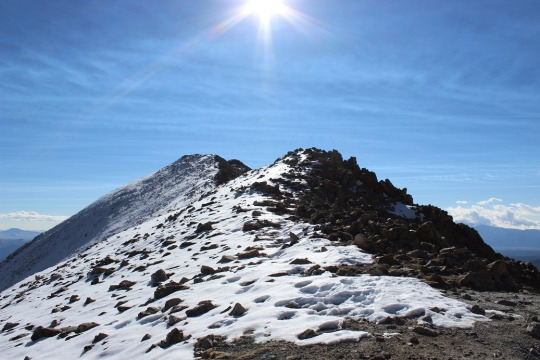
I’m proud to say I continued on up and over the second ridge

image

and summited my first 13er! (yes, I know it isn’t “official”)

image

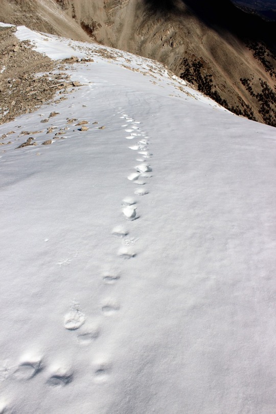
This is the first time I’ve forged a trail on snow, and I
was pretty proud of myself!  Oh, but I
had to prove I was in the right spot, so I took a picture of my Peakbagger app
indicating I was on the peak

image

And a picture of my GPS, showing where I was

image

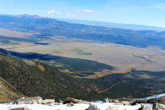
And as I looked across the mountain range, I snapped a
picture of this cloud that looks like a pufferfish?  Yoda?  Floating
majestically over Mt Antero.  

image

Then I headed back.
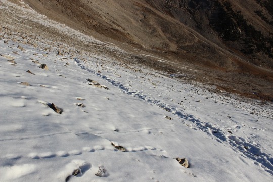
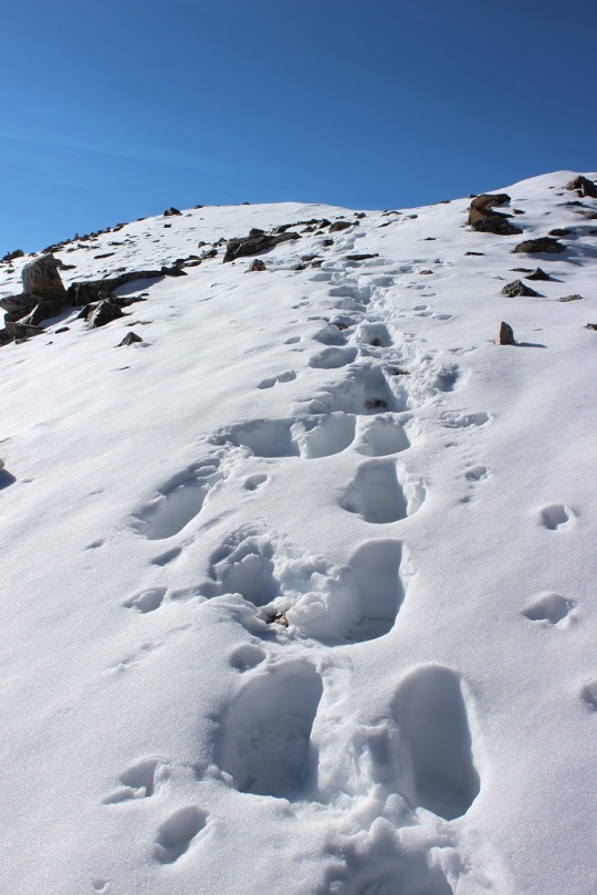
It was cool following my tracks!

image

So now I had a serious dilemma:  My microspikes were broken.  I’d slipped and fallen hard twice, but I knew
the hike would be much worse without them.
This is what I still had to hike (well, about 3 times this, as the trail
looped all the way around the mountain, remember those earlier snow pictures?):

image

So I made the decision to hike with the broken microspikes,
but to be very, very careful (slow).  I
kept my feet wide apart from each other:
I waddled, felt like a pregnant woman, and my pace was slow, but I didn’t
slip again!  I was excited to make it
back to 12000’ where the snow stopped and I could take off my microspikes.  This was also where I met my first hiker of
the day:  A newby without spikes but with
a good and realistic attitude (he was prepared to turn back but wanted to see
how far he could go).  I also met a group
of 5 or 6 friends hiking with a dog:  ON
A LEASH!  Major points to these
people.  They were friendly too!

image

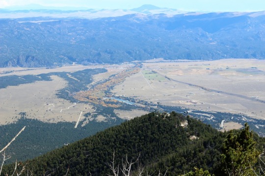
I made it back to my truck at 11:30pm, which wasn’t a great
time for a 7.5 mile hike, but I’ll allow it because I was hiking on extended
fields of snow for the first time, I forged my own trail and I was being extra
careful on the way down.  Here’s a
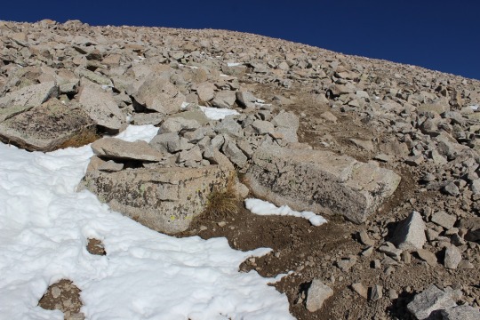
picture of the towers

image

Video:

14er Happy Hour – Cerberus Brewing Company

I’ve been trying to attend one of these
events for almost a year but I just haven’t been available on the dates they’ve
occurred.  I wasn’t available today
either, but our Rocket Troop meeting got cancelled at the last minute, so I
re-arranged an appointment for 8:30pm instead of 7pm and decided to go.  By myself.

Going alone was a conscious
decision.  There are several people I
could have invited, and who I would have enjoyed going with.  Rebecca even offered to go with me and be my
designated driver,  but I knew if I went
with someone I knew I wouldn’t have mingled and met other people, and that was
my main goal of attending this event:  to
meet other like-minded 14er hikers and pick their brains.

I don’t get out much, so I had Rebecca
and Emily help me get dressed.  Jeans and
a cami and heels.  I felt
respectable. 

Before leaving the house I quickly
posted to the event page: “Woohoo! I’m actually going to make it tonight! Long
time listener, first time caller… I’m excited to meet you all!”

I hopped in the truck and drove downtown
to the Cerberus Brewing Company.  I’d
never been there before but had no trouble finding the place.  Parking was insane!  My truck was too big for their little parking
lot, but after a 20 point turn I was able to drive back out and was extremely
lucky to find someone vacating their spot just across the street.  I pulled up as far to the curb as I could but
my truck still stuck out a little ways into the street.  I was a bit of a hazard but I was legally
parked. 

I saw people already seated that looked
like they’d be a part of the 14er crowd, so I quickly went to the bar to order
a beer.  There were 4 of us in a line
that took 20 minutes.  This was so not
cool!  Since we were at a brewery (not a
bar), everyone in line ahead of me wanted to try several different beers before
ordering.  UGH!  The line at the bar should have been for
people who already knew what they wanted. 
IMO, if you don’t know what you want, sit at a table and be served.  Anyway, the bartender didn’t think far enough
ahead to take the order of people who knew what they wanted while those in
front of them were still deciding.  When
it was finally my turn I asked for their largest option for beer (thinking it
was the 32oz) because I didn’t want to stand in that line again.  I had hoped on ordering fries or something to
eat as well (I hadn’t eaten dinner yet), but that wasn’t possible at the walk
up counter.   I was handed a 16oz Amber (which was very good
by the way) and headed out to the patio to meet some fellow hikers, resigned to
waiting in line again at a future point. 

I saw two men sitting and talking at a
table outside that looked like hikers, so I introduced myself. No, they weren’t
hikers but bicyclers who’d just finished a ride.  Whoops! 
It was then I realized everyone there pretty much looked like a serious hiker.  Gotta love Colorado!

We made small talk and I did get a lot
of great information from them about some trails at the Air Force Academy.  We chatted for about 15 minutes before I left
them to enjoy their time.

Next I headed over to a circle of chairs
where everyone seemed to be introducing themselves.  This looked like the right spot, so I made
myself comfortable and began chatting. 

Some notes from the evening:

  • The brewery was crowded, especially for a Wednesday night.  I’m not sure if it was because their beer is stellar (it was pretty good) or because they’re the only place to go in the area, but they were full from 6pm when I got there until 8pm when I left.  Great for them, not so good for me (I’m not a fan of crowds or waiting for beer).  I’ll probably visit this brewery again when I have more time and it’s less crowded. Just wondering when that may be?
  • I was overdressed.  Usually I say you can never be overdressed, but it was a bit of a detriment in this case.  The women there didn’t want to talk with me, and the men didn’t take me seriously until I’d talked with them a bit and proved I was a serious hiker.  Note to self:  wear hiking clothes next time.
  • Everyone was nice and cordial.  This was a nice surprise because there are a few trolls on the FB site and I was hoping this wasn’t a culture type thing.
  • There were probably 30 of us all together.
  • There were way more men there than women (by a 7 to 1 ratio at least I’d say)
  • There was a woman there who hikes Pikes Peak every month (she’s done this for 60+ months in a row).  I’ve never seen her on a trail, but she hikes during the week so our paths wouldn’t likely cross.  I’m really bad with names, but I think her name is Yin Ling.
  • Other than her, the other hikers had only hiked Pikes Peak once. This surprised me since its right in our backyard.  I was very surprised to hear most of them took the Crags route, and those who took Barr Trail took the train back down.  Hmmm.  They seemed to think I was crazy for hiking it so many times up and back.  Oh, and they were impressed with my time too.
  • There were people there of all different hiking abilities.
  • Half of us were first timers to the event, the other half were regulars.
  • I was by far the novice with only hiking one 14er, but gained points for hiking it so many times.
  • I met several people, but in no way had time to meet everyone.  I felt as if I had to cut a lot of conversations off early because I wanted to meet more people and I was time constrained.  I could easily have stayed a few more hours. I felt bad for leaving so early.
  • No one had a regular workout routine, they just hiked 14ers. 
  • I’m really bad at remembering names, so here are the names of some of the people I met, in hopes I’ll remember them better:  Stephanie, Joe, Matt, Scott, Yin Ling, Matt, David, Karthik (KK, works for CTU, West Cost Swinger, from India)

I felt as if everyone was asking me
questions, and I didn’t get enough time to ask them questions back. 
I did learn several things however.  Flat tires seem to be a problem on many of
the 4WD trails.
  I should do these with
other people and preferably with someone who has a jeep.
 

At one point I asked the group I was
sitting with “So, what allows you to hike?” and was met with blank stares. 
I was sitting in a group with all men, and
this apparently wasn’t a concern to them.
 
Their hobby was hiking, so they hike. 
End of story.  It’s not the same
for women hikers.
  I’m a full time mom
and I work full time, but my kids are getting older.
  Having my kids in school and not working
Fridays is what allows me to hike at this point in my life.
  Once again, this concept was foreign to them,
so I moved on to another subject.
  Hiking
goals.
 

I was surprised at how many of them had
already hiked all of the 14ers and are now working on 13ers. I met one man who
lives 2 blocks away from me who’s already hiked them all (Scott Davis). 
His advice was good advice:  the shortest or standard route isn’t always
the best route.
  Many of them are boring
and I should seriously look into all routes before making the decision of which
to take.
  This seems like pretty good
advice, and something I probably wouldn’t have considered.
  We exchanged phone numbers and while he isn’t
really interested in hiking the 14ers again, he’d be open to giving me advice
on them all if needed.
 

This event was really a good way to meet
people with similar hiking goals.  Everyone
was sharing information on previous trips, planning new ones, talking about
gear, etc. I saw several groups make plans for backpacking trips and several
14ers right there.  There are a bunch of
peaks I know I’ll want hiking buddies (especially ones with technical gear and
possibly a Jeep).  I need to figure out
how to be a part of this, which means I’ll definitely be attending the next
14er Happy Hour (if I can make it… I’m seriously going to try).

I left at 8pm because I had an 8:30
appointment, but I left wanting more. 
After meeting other 14er hikers and listening to their stories I’m more
excited than even to begin this journey. In the course of taking with these
people I realized if they can do it, I can do it.
  As I’ve told many hikers while hiking:  Start and stop stopping.  Just keep going and you’ll make it. There’s a
book title in there somewhere.

14er Challenge Poster

Woohoo!  Look what arrived this week! 

I’ve actually had the poster for a few days, but I didn’t have a frame, so this afternoon I went out and bought one.   The poster looks much better inside a frame, even if it is a cheap one.  I bought a simple frame at Walmart because I plan on opening and closing it several times over the next few years and don’t want to invest too much on something that will most likely break with overuse.  Once it’s complete I’ll  get a nicer frame for the poster.  I hung it outside my bedroom door.  Rebecca noticed it when she got home:  “Oh, I see you already have your poster hung up.”

This 18 x 24 inch poster was designed as a kind of log of your 14er hikes.  54 of Colorado’s 14ers are represented from original paintings of the summits by Robert L. Wogrin.  There’s a small rectangle below each peak for you to write the date you successfully summited each 14er.  I plan to write the summit number in the boxes instead of the date, and I also plan to put a picture of me at the summit over each image as I progress.  In the photo I’ll most likely be holding a cardboard sign indicating the name of the summit, elevation, and date.  Yes, I know that’s a predictable and sort of following the crowd type of thing, but it’s what I intend to do.   I’m open to other suggestions?

Another idea:  Collecting a small rock (maybe 1.5 inches?) from each summit, then writing the name of the summit and elevation in Sharpee on the rock. If I’m successful, I’ll have 54 rocks from the highest points of Colorado. 

Hiking Goals: The List

I
actually made this decision a few weeks ago but I’ve been so busy I haven’t had
time to write it out. 

I’ve
never had the goal of hiking The List
.  I know a few people who’ve done all 54, and a
few others who are currently attempting them, but I’ve never felt the pull. Until
recently.
 

The
increased parking fee I incurred last month at Barr Trail did it: 
I came to the realization I could either
spend $20 to hike Pikes Peak over and over again, or I could spend that $20 on
gas and add to my knowledge of 14ers.
 

So
I did some research. 
OK, quite a bit of
research.
  I pulled up an interactive map
of all 54 14ers in Colorado (yes, I know that number’s debatable) and seriously
looked into their complexity ratings.
  I
put together a spreadsheet, detailing elevations, round trip route lengths,
technical difficulty and drive distance from my house.
 

Over
75% of 14ers in Colorado are listed as “easy” or “moderate”, and all are within
a 6 hour drive.  
Most are under 10 miles
round trip, and attainable in a day, even with the drive. There are a few that
require technical training, and a couple of weekend backpacking trips are
necessary to accomplish some in the southwestern part of the state due to their
remoteness.
  But they’re actually quite
doable, and I’m in pretty good shape, so I don’t need to prep to get started. There
are a few where I could actually bag 2, 3, or 4 in a single day!

In
the beginning I was thinking I’d just do a couple this summer, but the more I
researched the more excited I got about actually making a goal out of The List
. 

I
bought the book 14er Disasters. 
I love these types of books because I can
learn from others mistakes.
  Hiking a
14er is no joke.
  There are many
obstacles to hiking at such an elevation, not to mention the distance you are
from help/rescue if something were to go seriously wrong.
  Which it does, even to the most prepared of
hikers.
 

The
first few pages of 14er Disasters
mentioned
The List was first completed in 1923.
Hmmmm.
  2023 is just a few years
away.
  I did the math, and I could
realistically conquer all 14ers by the 100
th Anniversary of the
first duo to complete them.
 I love
goals, and this actually sounds exciting.

So
I registered on 14ers.com and made a profile. 
My accomplishments so far are actually quite respectable: I have
backpacking experience.
  I’ve summited all
the highest mountains in Southern California, as well as summiting Pikes Peak
12 times. Yes, I’ve only done one 14er, but I’ve hiked it 12 times.
  I think that gives me pretty good experience
with what a 14er has to offer in the way of weather, exposure, and the physical
toll the altitude takes on your body, not to mention the exhaustion from the hike
itself.
 

So
that’s my new goal. 
I’m currently
working out my summer hiking schedule, but I figure I’ll start with a few “easy”
ones just to get them out of the way and work my way up from there.

No,
I don’t plan on hiking alone. 
I will if
need be, but as soon as I get a schedule together I’m going to make the dates
available to all my Girl Scouts.
  I know
a bunch of them will be excited at the opportunity to hike multiple 14ers this
summer, in addition to Pikes Peak.
   Starting with “easy” ones will help me gauge
who’s serious enough to conquer some of the more difficult routes.

1
down, 53 more to go!