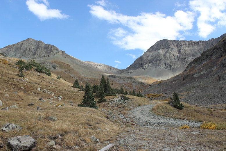
I really wanted to do Atlantic and Pacific together, but until April I have limited time schedules for hiking (I need to be back at my truck by noon to make it home in time to pick up my daughter from school, so it’s hikes under 8 miles until then). The weather indicated Atlantic Peak would be a good choice for today, so I went for it. This was only supposed to be a 4-6 mile hike and I wanted to break in my new winter hiking boots. They were supposed to be lighter and warmer than my Sorrels, but I was skeptical so I wanted to use them on a shorter hike before committing to longer distances.
I arrived at the Mayflower Gulch trailhead at 5:15am to 14* weather, much better than the -5* weather of last week in the San Juans. I was also pleasantly surprised to find it was right off the road: no off road driving for me today. There was one other vehicle (a Subaru) in the lot, and while the gate was open up to Boston Mine I decided to park my truck at the lower lot and hike in.
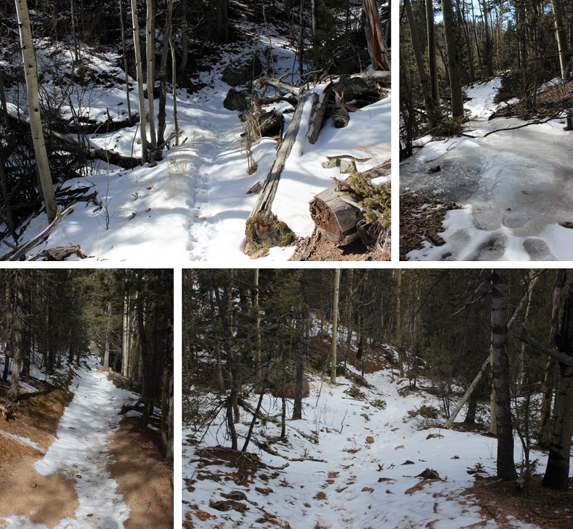
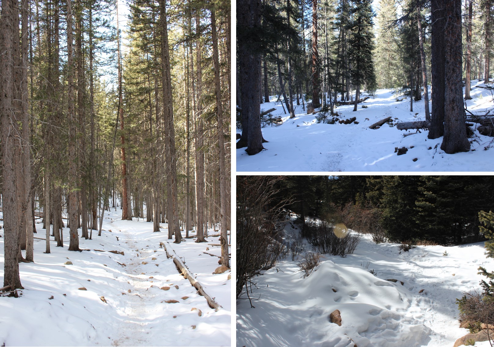
The lower lot was icy!!! I put on my microspikes in the truck and gathered my gear. I set out at 5:30am. It was very peaceful hiking at night. Silent. Very silent. No moon, but the stars were magnificent! The only sound was the snow falling off tree branches and onto the trail below. The trail was tightly packed down by other hikers, snowshoers and skiers.
A 4WD vehicle could have made the icy drive, but since this hike was so short it didn’t seem worth the extra mile and a half. I made it to the Boston Mine area before sunrise and put on my snowshoes in the dark. I was lazy so I kept my microspikes on and just put my snowshoes on over them. If I needed to take them off it would be a quick transition and maybe I could keep my gloves on the entire time (saving my fingers from the cold).
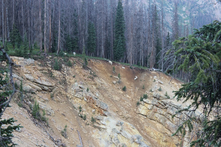
Oh, btw, this fence is not the height of a normal fence… it’s probably half the height (so the snow looks deeper than it actually is).
Snowshoes ended up being a great idea, because while the trail was packed down, as soon as I went off trail I started sinking to my knees, even while wearing my snowshoes. I looked for a trail across the gulch, but it looked like I was the first since the last snowfall so I broke my own trail.
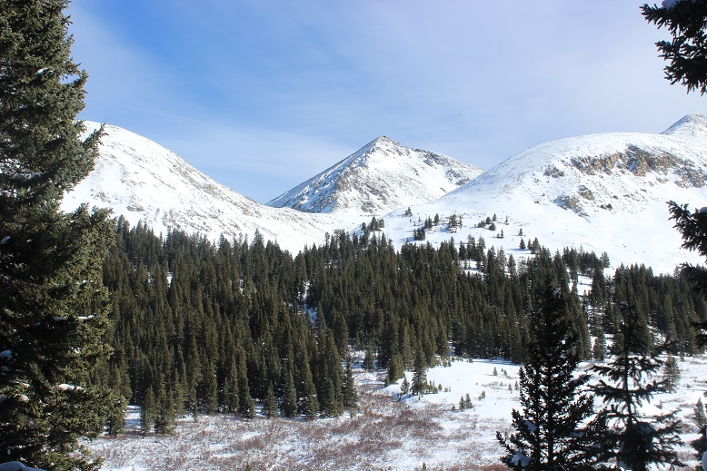
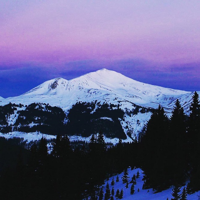
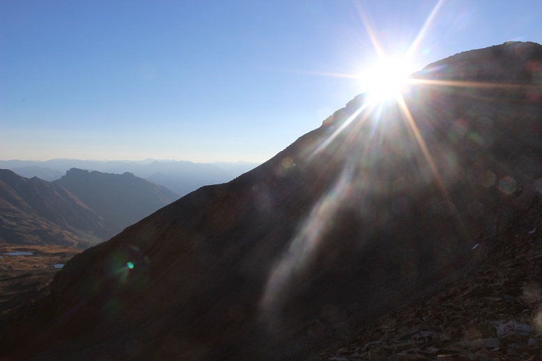
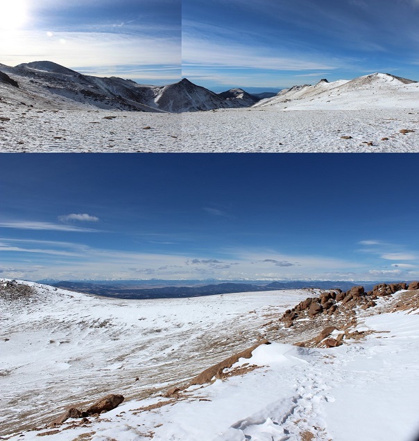
The sun was beginning to rise, and Jacque Peak looked beautiful.
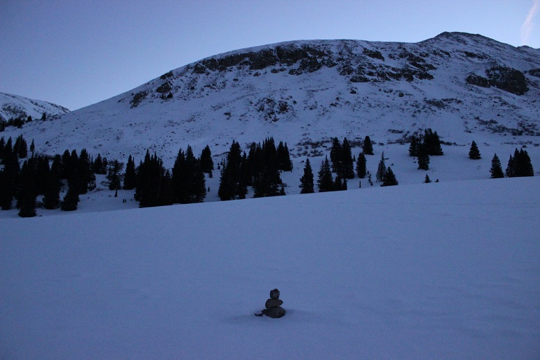
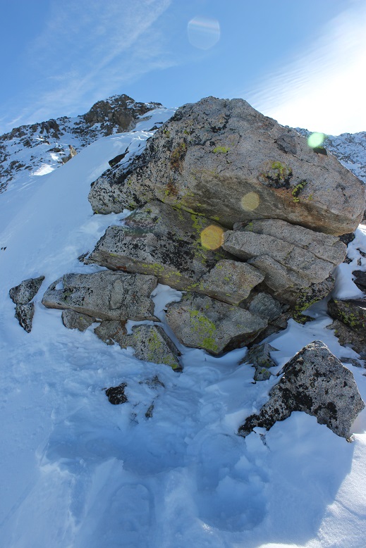
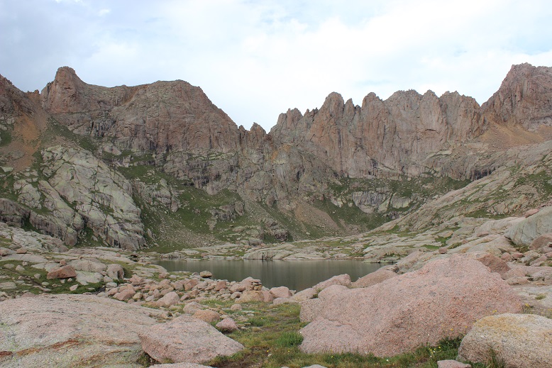
The snow was sugary and made snowshoeing difficult. I’d be fine for a few yards, and then plunge up to my waist. This was a serious problem in the willows, but I made it across the gulch and was surprised to exit and stumble upon a cairn! This was an unexpected treat! I found about 4 cairns on the entire route, always unexpected and sometimes on my way back down.
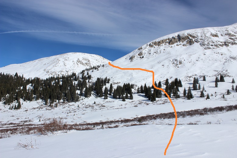
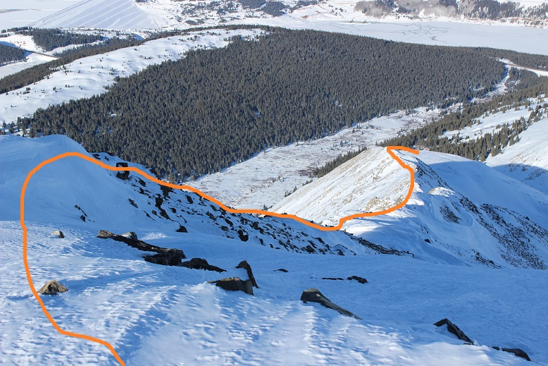
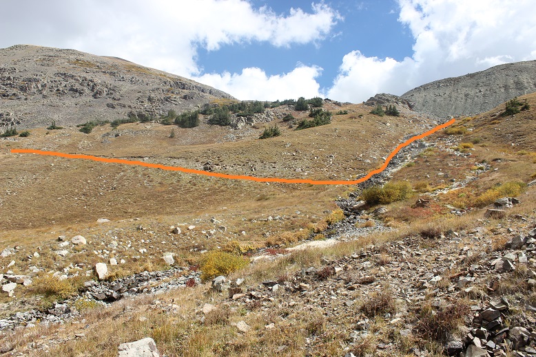
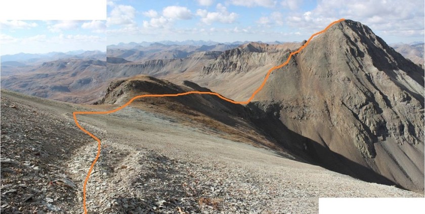
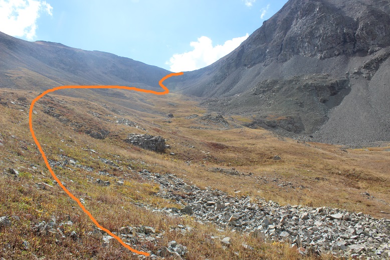
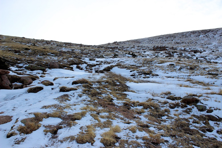
After crossing the gulch I was supposed to follow Mayflower Creek up to Atlantic’s west ridge, but the snow didn’t look stable and it looked really deep, so I stayed higher up on the hillside. This was great (early elevation gain) but there were times I was seriously worried about avalanche danger. It wouldn’t have been an intense avalanche, but I could see signs I should take an alternate route back once it warmed up. So I was slow in traversing the slope, but careful and ultimately safe.
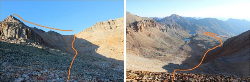
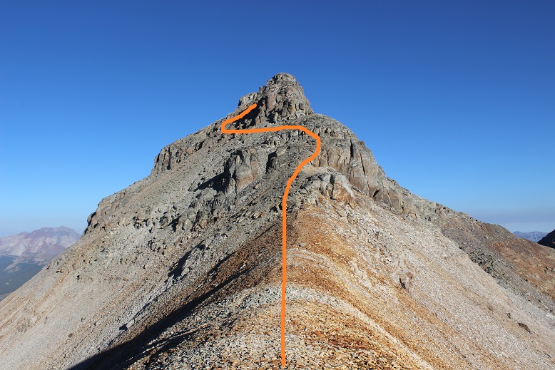
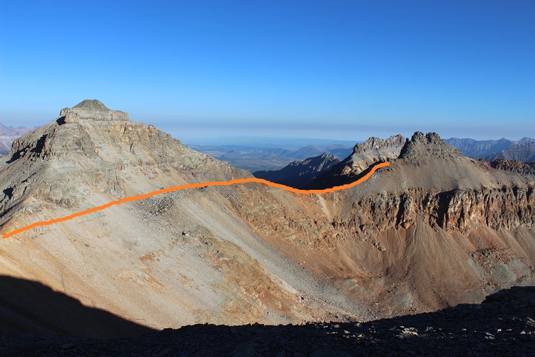
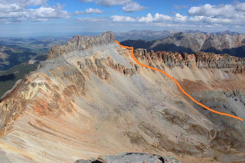
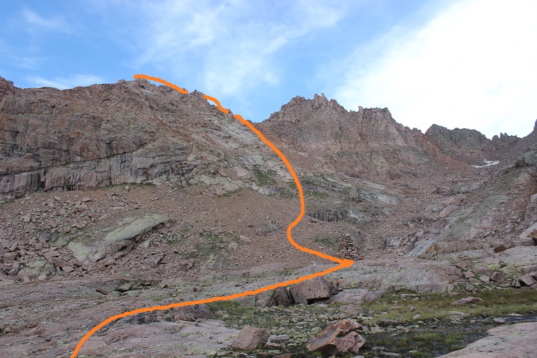
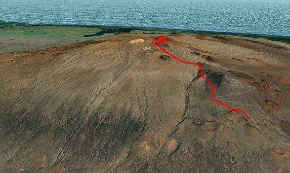
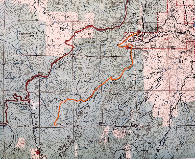
Here’s the route I took
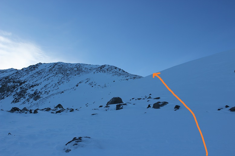
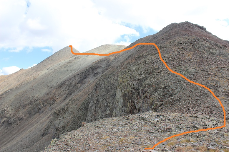
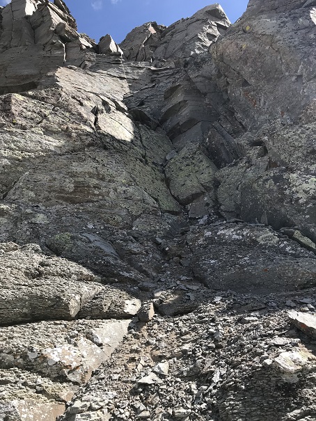
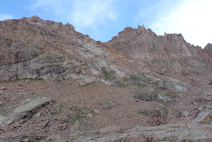
My next task was to hike Atlantic’s lower west ridge. This ended up being more difficult than anticipated: the snow here was very consolidated, unlike the sugary snow on the slopes and gullies. My snowshoes weren’t going to cut it. I took off one snowshoe and tried it with my microspikes. They became ice skates. Hmph. Ok, I was going to need to get creative. I put back on my snowshoes and got out my ice axe. This wouldn’t have been a problem with two ice axes or two ice picks and crampons, but I only had one ice axe and I hadn’t brought my crampons (I thought it was still too early). So I used my ice axe to drill a hole big enough for my left hand and then struck the snow with the axe and my right hand for support and lifted myself up. My snowshoes used the holds I’d made for my hands. This worked very well and I was able to gain the ridge in no time at all. (Note to self: It’s time for crampons).
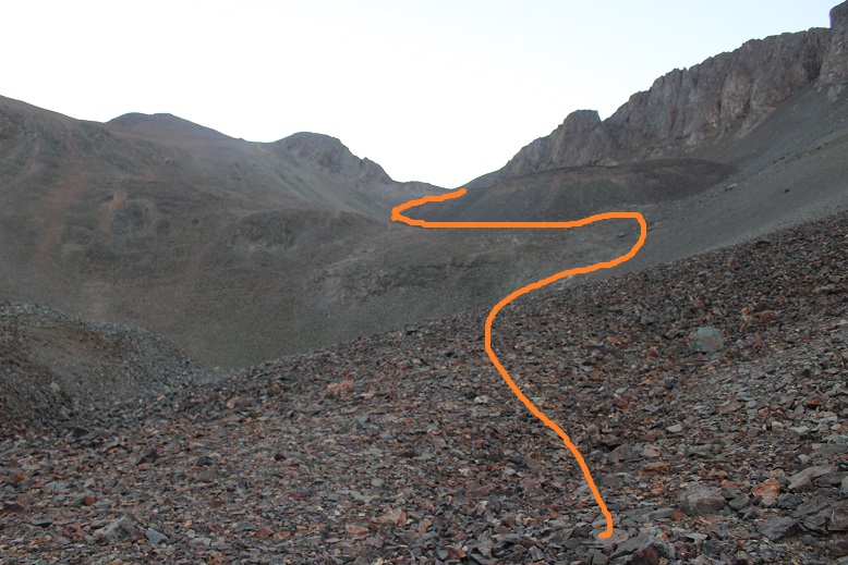
Here’s a look back on the route
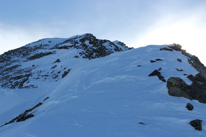
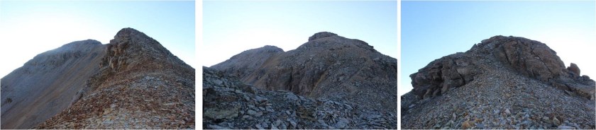
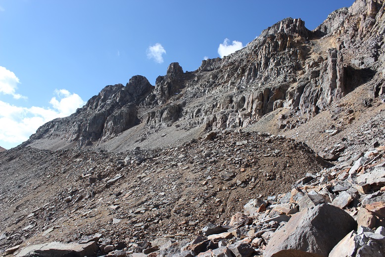
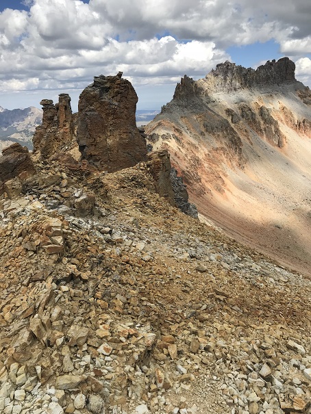
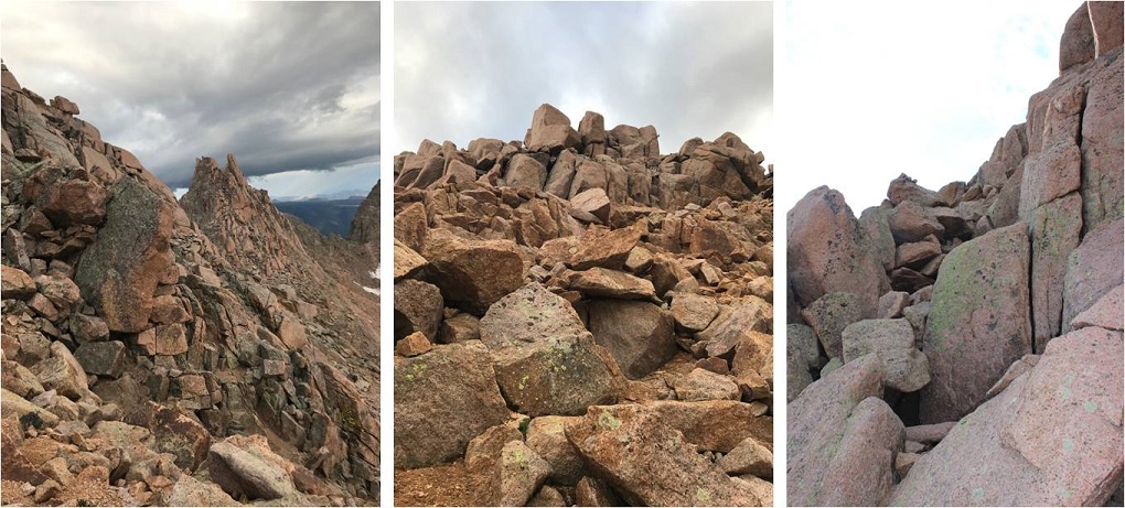
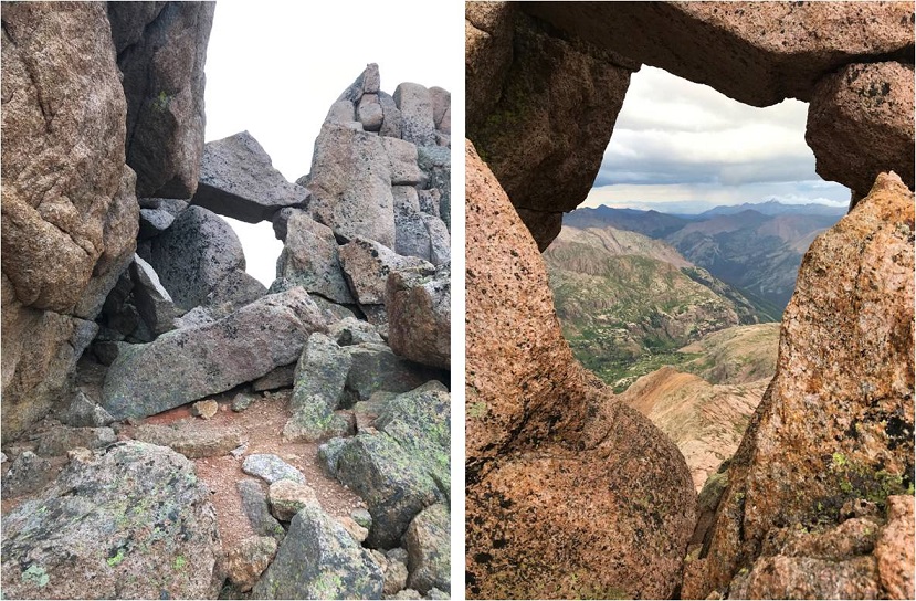
From here I was just supposed to follow the trail to the summit, but there wasn’t a trail, and in fact, at about 12,700’ I encountered some of the most difficult terrain of this hike.
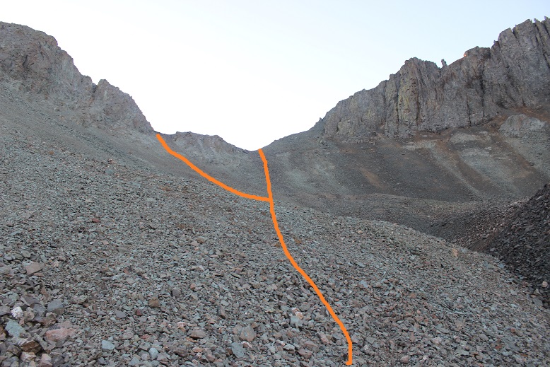
This is where I wanted to turn back. I seriously considered it. The snow was intermittent and what snow there was was sugary and covering loose talus, so I couldn’t get a good grip on it in my snowshoes. I took them off again to try it with just spikes and it was even worse! My microspikes were of no use: I really needed the stability/flotation of snowshoes. Even though they weren’t perfect, they were a big help. This area took me much longer to navigate than it should have, but I didn’t quit and I didn’t turn back. I gained this ridge and was met with this:
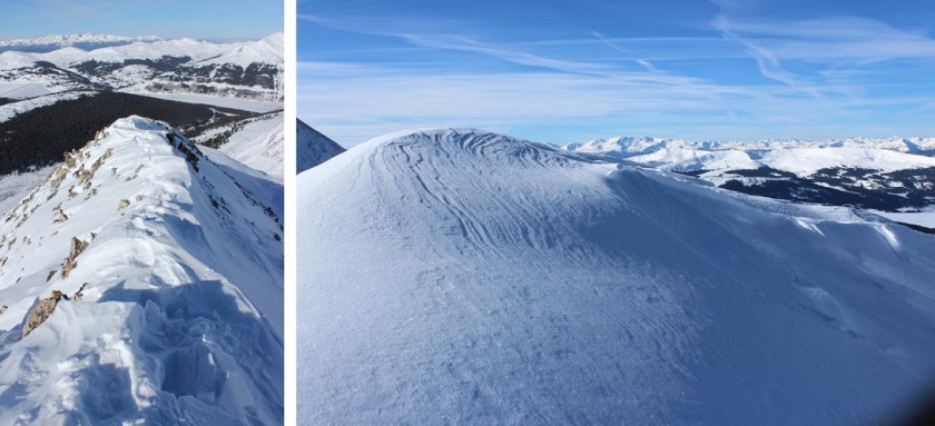
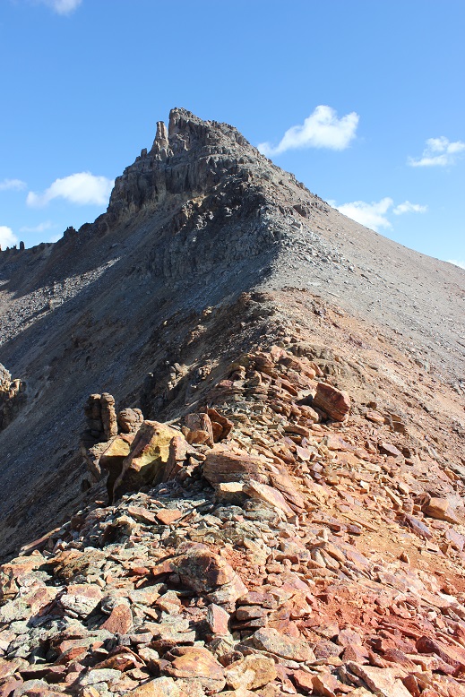
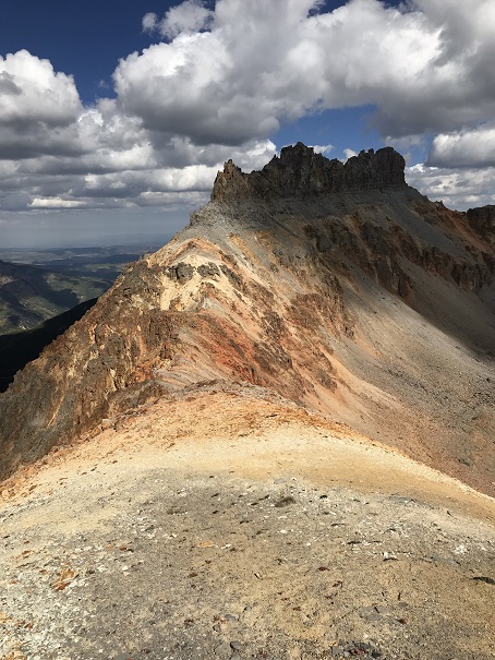
Wow. That ridge didn’t look too difficult in normal conditions, but I could already see this would be a challenge due to the unpredictable snow. Maybe not a challenge for seasoned snow summiters, but I’m still new to this. There was snow, lots of cornices beginning to form, and a narrow ridge to navigate. I forged on ahead.
Luckily a mountain goat had been here last night and gave me some tracks to consider. There were times I didn’t feel safe following it’s tracks, but they did give me a good general direction to follow, which was directly on top on the ridge.
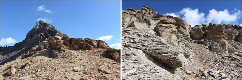
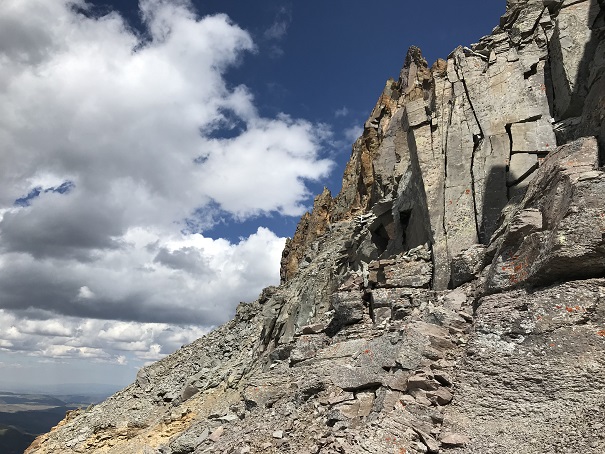
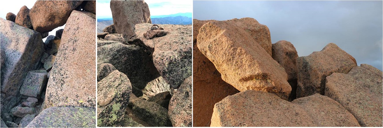
I’d reach one summit and find another, which was frustrating, but I knew everything I encountered was within my abilities and even a bit challenging. I came across a few sections that would have been class 2 if there hadn’t been snow, but with the snow (and instability of said snow) I decided it was safer just to go straight over the ridge. This turned the hike into a class 3 climb, and with snowshoes made me a bit clumsy (but safer than without).
This was one of those learning opportunities where I was scared at times but knew I could do it so I kept pushing forward, even though there were many times I wanted to quit and come back in the summer.
Here’s the route I took:
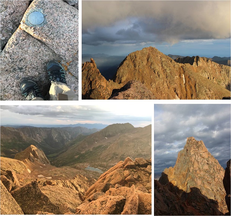
The trek wasn’t long, and I wasn’t tired when I reached the summit, but I was cold. Luckily my phone and camera were working, although my phone cut out halfway though the first video and I had to take another one and then it shut down. I plugged it into my portable charger and took pictures with my DSLR. I summited at 9am.
VIDEO:
While it was cold it wasn’t windy, so the cold was bearable. I stayed on the summit much longer than I normally do, taking pictures and marveling at the beauty of the mountains with snow.
I considered traversing Pacific Peak as well, but didn’t think I’d be able to do it successfully with my time constraints. The class 3 route looks doable now though, so I may be back in the next few weeks.
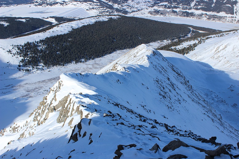
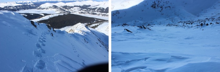
Here’s a look back at the route
The trek back was easier than the hike in because I just followed my tracks (and didn’t look down). Looking down would have caused unnecessary anxiety.
Those ridges were something else!
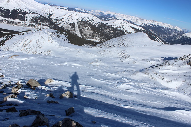
Of course I took a shadowselfie
I decided to follow the creek down because that was what I was supposed to do and I was seriously worried about avalanche danger on the route I’d taken up the mountain. I’m still learning about avalanches, but know some of the initial signs and what I was seeing wasn’t making me comfortable. So I took the creek, but this proved difficult as well, as out of nowhere I’d sink up to mu chest in soft snow and then have to work myself out. This happened many times and was frustrating, but I still felt safer than on the slope above.
Just before hitting Mayflower gulch my toes started to hurt: the new snow boots were fine, but the snowshoes and boots combination was cutting off circulation in my toes and trekking downhill was beginning to hurt. This hadn’t happened in my previous boots, and is something I need to consider.
Also, I lost my phone. It fell out of my pocket and I had to retrace my steps ¼ of a mile uphill to find it. That wasn’t fun. I found it buried in snow (but attached to my bright orange solar charger). I picked it up and trudged back down the hill and across Mayflower Gulch to Boston Mine.
It was a beautiful day! And warm! I took off my gloves but had to put them back on again once I made it back to the trail (and shade). Have I mentioned I love my new gloves!
My new winter books are ok, but despite my double tying them and folding them under my laces they still came undone while hiking, which isn’t an option for me since I can’t tie them wearing mittens. I may try safety pinning them next time.
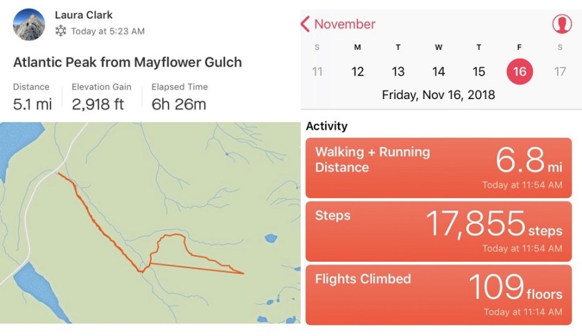
I made it back to the trailhead at noon and looked at my STRAVA map. Hmph! This wasn’t right: It showed my trek to the summit, but it seems it stopped working there and picked up again where I found my phone in the snow after losing it (please don’t attempt to take that straight line: it’s not safe!!!). So while the elevation gain is most likely correct, the trek down and mileage definitely are not. My iPhone told me I’d hiked 6.8 miles, so I’m going with that for mileage. The hike was 5.5 hours.
Here’s my Relive map (which is also false since it did that straight line thing from the summit to where I lost my phone).
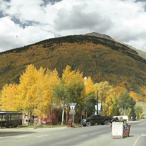
My drive to the trailhead took me through Silverton. I’d heard the fall colors weren’t supposed to peak here for another 2 weeks, but right now it looks beautiful.
I had conflicting directions on how to get to the Burns-Gulch trailhead, so I brought both with me. From Silverton I took County Road 2 past Eureka on a 2WD dirt road, and ate the dust from off road vehicles driving ahead of me the entire way. For a Monday afternoon it sure was crowded: Leaf peeping season is definitely in full swing!
I made it to the base of the trailhead on the Animas River and my directions ended but I knew this wasn’t where the 4WD trail began. So I pulled up a GPX file of the route to see where I needed to be: about 2 miles up a narrow shelf road.
The road was much narrower and steeper than it looks and filled with bowling ball sized rocks. I took it slow: this road was more difficult than I’d anticipated (but nothing my truck couldn’t handle). I just hoped no one would drive towards me from the top: There was no way I could turn this truck around on such a narrow road, and passing another vehicle wouldn’t be easy.
There was a campsite at the 4WD trailhead at 11,720’ and no other vehicle in sight. Sweet! It looked like I was going to have the site all to myself for the night.
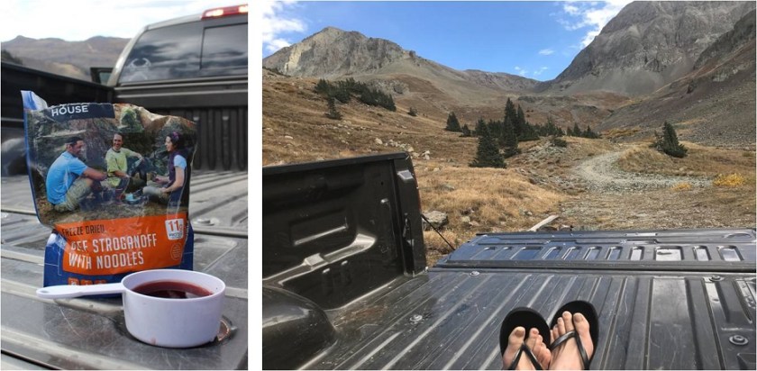
I got to work making dinner: Mountain House Beef Stroganoff. When it was ready I poured myself a glass of wine in the measuring cup I brought for making dinner, sat back, and enjoyed the view.
Life is good! Sitting in the bed of my truck looking at the mountains was so relaxing. As I was sitting there I heard a creek to my right and got up to investigate. This was wonderful! It was about 10 yards from where I’d parked my truck. I enthusiastically washed my hands in the running water. They were gross from today’s adventure and it felt good to have clean hands and fingernails again. I got up to turn around and head back when my left sandal broke. I mean really broke, like duct tape can’t fix it broke. Drat! I was going to have to tiptoe the 10 yards back to my truck without wearing shoes. The first step I took landed my left foot on a thistle. Wonderful. I made it back to my truck, poured myself another glass of wine and spent the next half hour picking splinters out of my foot (mostly on the heel and arch). I looked around at the mountains: Life was still good!
I got out my maps and route info for the next day and tried to identify the peaks around me and the best route to take (I had several options). I studied my chosen route until I felt it was time to get some sleep: it was starting to get cold.
I decided to sleep in the cab of my truck because I fit perfectly across the back seat and because I could. Two shots of whiskey later I was ready to go to sleep. I laid my head on my pillow and a fly landed on my arm. I thought about how much fun having a fly buzzing around me while I was trying to sleep would be and debated whether or not to open the door to let it out. In the end I decided I’d rather not let all the warm air out in doing so, so I made a deal with the fly: “Fred “(I named him Fred)”If you promise not to buzz around me all night I promise not to kill you right now”. Fred flew away to relax on my steering wheel and I fell asleep thinking this wasn’t a bad way to spend my last day of being 37.
I woke up at 11:11pm. This isn’t unusual, as I normally only get 4-6 hours of sleep a night. Obviously my body was ready to get up and start my day. I however was not. I took 3mg of melatonin, washed it down with another shot of whiskey, and spent 5 minutes star gazing before falling back to sleep.
My alarm woke me up at 5am. Why, oh why, oh why did I choose to sleep at a trailhead on my birthday? I hate sleeping at trailheads! I’m always cold and have a hard time getting going and all I really want to do is stay in my nice warm sleeping bag where it’s nice and warm. Sleeping.
Why hadn’t I done the sensible thing and reserved a hotel in Ouray?
Ugh. I could smell myself. Or was that my socks and shoes on the floor recovering from yesterday? Both. Definitely both. Well, the day wasn’t getting any younger. I needed to be off, so I slowly started through my morning machinations, taking much longer to get ready than it would have taken me at home. My coffee was cold. My hands were cold. It took me almost an hour but by 6am I was finally ready to go.
I decided to start by hiking to the Jones-American saddle, which I discovered isn’t a very popular route (most people start with the Jones/American saddle). The trail starts at the campsite and heads directly north up a hill, then east. (Sorry, no pictures: I did this in the dark and planned to get pictures on the way back, but there was an adventure that happened….)
I followed the road to a drainage and just headed up what was trying desperately and failing to be a waterfall.
From here I followed the drainage up a basin and to the right. Just continue sticking towards the bottom of the drainage and heading right.
I passed a very small pond (it’s been a dry year)
and navigated up the rest of the basin. There’s no established trail or cairns. This looks like a great route to ski in the winter. This is the route I took to the saddle
The base of the saddle is where I ran into trouble. I knew I had to gain the saddle, but neither of the options I saw looked better than the other.
I could have gone either left or right. I chose left. I chose wrong. As I got closer and closer to the saddle the ground became less and less stable and the path to the right looked more and more appealing and less steep. The ground wasn’t like loose scree, but more like compact sand my shoes couldn’t grip. It was slippery and I was dangerously close to sliding all the way back down the slope. At this time I realized this must be a snow route: perfect for skiing down or snowshoeing up.
I decided to aim for the rock wall area to the left, as it looked like it had more stable dirt around it. It didn’t. In fact, it was just as loose and slippery as the rest of the scree. I made it to the rocks and my first thought was “Why don’t I have my helmet? I need a helmet for this!!!” I had a helmet, it was just back at the trailhead in my truck because this was supposed to be a class 2 hike. The rock I’d wanted to climb was more of a rock wall than a rock couch. I’m talking straight up with hand and foot holds that crumble out from under you when you grab them. But it felt safer than the dirt/scree area. I was shaking, but I made it. I wouldn’t recommend it to anyone, and I’m glad I did this route first instead of last (I’d of had to re-summit Jones again because there was no way I was going down that unless I was on skis).
Here’s a look at the route I took to the top of the saddle. I know it doesn’t look like it but this was the safest option since I hadn’t taken the route to the right.
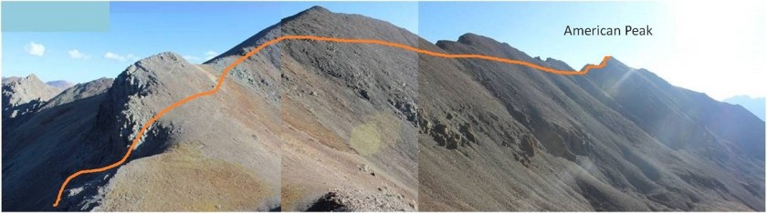
OK, now that I’d gained the saddle I looked at my route to American Peak.
Oh yeah… it looked like I’d be hiking into the sun again today. I put on my sunglasses and had at it. Here’s a clearer picture of the route from later in the day. Why does the peak I’m climbing always have to be the LAST peak on the ridge?
Most of this hike across the ridge was easy. It was a well traveled path with even a few cairns in places. It became difficult at the base of the last bump before the summit. For about 200 feet the rock became extremely loose and there was evidence of rockslides everywhere. It was difficult to find good footing, and once again I longed for my helmet. I’d read this was the easier ridge of the three I’d do today, but I disagree: this West Ridge to American Peak was the most difficult ridge I did today, but only the last part of the ridge. Here’s the final pitch to the summit
I summited at 8am
American Peak:
Here’s a look back on my route, and my next peak: Jones Mountain A.
I reversed my steps (the ridge was easier on the way back down) and made my way to the Jones/American saddle. I turned and faced the ridge. Here’s the route I took:
Believe it or not the initial climb up the ridge was more stable than the ridge on American Peak, it had some steps but still had scree.
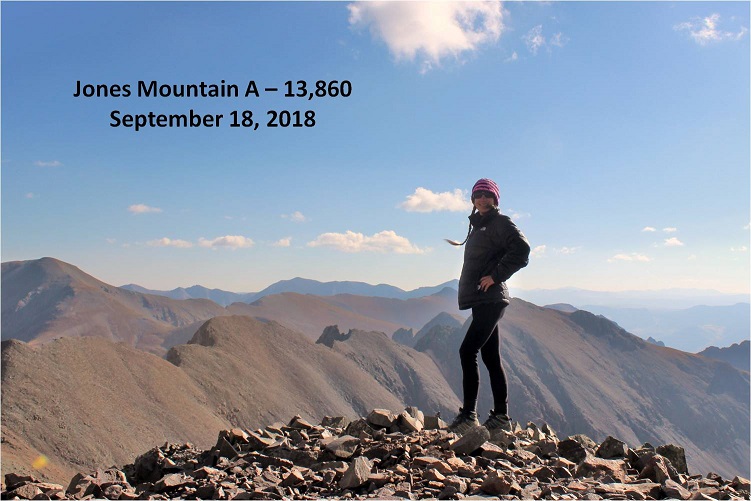
About halfway up the terrain changed and I walked a class 2 ridge to the summit of Jones Mountain A
I summited at 9:15am
Jones Mountain A:
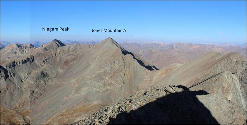
Here’s a look back at American Peak and what I consider the crux of that route
Now it was time to focus on Niagara Peak. The trail from here to the peak is well established. I just followed the trail down Jones Mountain A and up the ridge of Niagara Peak.
And a look back at Jones from the saddle
On my way down from Jones I saw a man hiking with his two dogs. I was surprised to see him, as I hadn’t expected to see anyone out here today. He was nicely and appropriately dressed for hiking with both a GPS and Walkie Talkie on either strap of his backpack. His dogs were leashed, well groomed and very well behaved. We stopped and discussed the Niagara/Jones saddle and descent, to which he didn’t think his dogs could make the loop. He would most likely head back the way he came. We parted ways, him to continue up Jones, and me towards Niagara Peak. He was the only hiker I saw all day.
Just after passing the hiker I was surrounded by a flock of birds. They kept following and avoiding me on the trail. I considered it good luck and figured there were 38 of them…
Birds:
I made it to the saddle of Jones/Niagara and looked at the ridge. There is a path but this is another class 2 ridge that has some steep sections and lots of scree. If I haven’t already mentioned it, microspikes would be helpful on this route, even without snow.
Here’s a picture looking back on the ridge
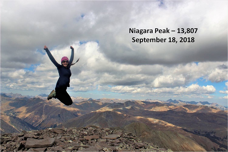
I summited Niagara Peak at 10am. Oh, and guess what? Niagara was my 38th 13er! I summited my 38th 13er on my 38th birthday! Very cool! BTW, 38 feels great!
Niagara Peak:
What a beautiful day! I’d considered hitting unranked 13ers Crown Mountain and North Crown Mountain, but I wanted to make it back to celebrate my birthday with my kids (and my son’s birthday: he’s headed for Basic training on Monday and he’ll turn 18 during boot camp, so I’d like to celebrate early). If I left now I could be home by 6pm, just as the kids were making it home as well.
So I turned and headed back to the Jones/Niagara saddle. This trail was much easier to navigate than the route I’d taken up. This route had a trail for 90% of the way, and where there wasn’t a trail you could see where it connected further down.
This is the route I took down. It hugged the right (east) ridge. This path took me back to my truck and the 4WD road that was obvious from the Jones/Niagara saddle.
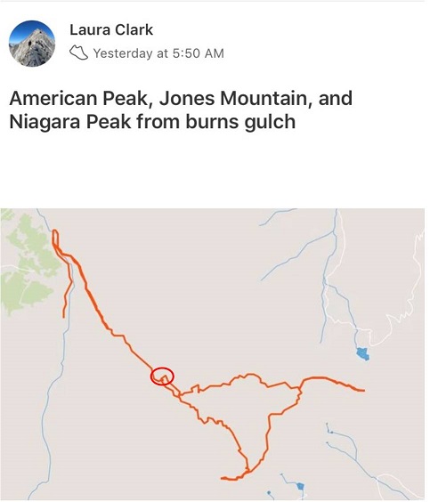
Here’s a copy of my GPS tracks. The red circle is where I parked my truck overnight and began/ended my hike. The tracks are a little off: I forgot to hit stop on my tracker because of the adventure below… but it might help others who want to know how to get to the upper trailhead
As I was descending back to the Burns Upper 4WD trailhead where I’d parked my truck I noticed the man I’d seen earlier and his dogs walking around, looking at my truck. Hmmmm…. That was odd, but maybe they were just taking a break and checking out my truck. It is an awesome truck. I kept an eye on them as I kept hiking. Within half an hour I was back at my truck, and the man and his dogs were still there. He asked me a bit sheepishly if he and his dogs could hitch a ride down to the lower trailhead: his dogs were tired and their feet were sore.
Of course they could ride down with me!
He was happy and let me know he’d hiked up with his wife but she’d turned back much earlier in the hike and he’d continued on with the dogs. She was waiting for them at the lower trailhead by the river crossing.
Immediately my estimation of him as a person grew: I love it when a man who’s married lets me know early on in conversation he has a wife. It sets the tone in a positive way, and I respect a man who wants other women to know he’s married.
I cleaned up my truck (it had stuff from the past few days strewn all over since I’d also used it as a tent) and apologized for the smell (both from my dirty clothes and, well, me). He was happy to have a ride down and put the dogs in the back of the truck. They indeed looked tired.
I navigated the 4WD road as slowly as I could, cognizant of the fact I had two dogs in the back. I usually take these roads at a quick speed, but right now I was gingerly maneuvering around the rocks and unfortunately not avoiding them all. We hit a few big bumps, and my passenger kept looking back to make sure the dogs were ok.
The 2 miles took us about 20 minutes, and we talked about our jobs, my kids (I can talk about them all day), vehicles, and his life as a Doctor and his wife being a Veterinarian. They were staying in Ouray for vacation and are 14er/13er/hiking enthusiasts.
He also mentioned this was the first time his dogs had ever been in the back of a truck. I tried to take it a little slower, knowing the road was rough. About halfway down the road we ran into a Jeep heading up. It took some careful maneuvering, but we were able to pass each other on the narrow road. I was pretty proud of my driving skills, and thankful the other driver was willing to work together so we could both pass each other.
When we made it back to the bottom of the road I decided to navigate around the river instead of driving across it because of the dogs in the back. We pulled up next to his vehicle, where his wife was waiting. I jumped out of the truck, opened the tailgate, and… no dogs! What? Where were they?!?!?
When I announced the dogs weren’t there the woman had a shocked look on her face, and I felt as shocked as she looked. After some quick discussion we came to the conclusion the last time we’d seen the dogs in the back of the truck was around the time we’d passed the Jeep (that was the last time we’d checked). Well, there was no way we were going to have two lost pups on my watch. I knew their car couldn’t make it up the road, and I was determined to find those dogs (once they were in my truck I felt responsible for them), so I offered to drive the couple back up the road to look.
I drove very quickly this time, driving across the river and up the side of the mountain at a swift speed, concerned time was against us. Also, without the dogs in the back I didn’t have to be gentle. It wasn’t lost on me how I’d thought this road was difficult the first time I’d driven it, but now I wasn’t quite so worried about the road: I was worried about finding those dogs.
One of the dogs was white and it’s currently fall so I figured it would be easy to spot in all the brown grass.
We ended up finding them about halfway up the road, just before where we’d passed the Jeep. They were sitting side by side in the shade under a tree, panting with happy smiles on their faces. Luckily the hike had exhausted them and they hadn’t felt like running. They were also well trained dogs.
This time we put the dogs in the cab of the truck for the ride down. I was able to make a 9 point turn on the shelf road and headed back down to the lower trailhead. It was a good ending to the hike.
I was in a bit of a hurry now to get home. As soon as I hit cell service my cell phone blew up with tons of messages and important things I needed to address. I had the whole 7 hour drive home to think about everything and make phone calls. As I exited Silverton Fred landed on my hand and then quickly flew away. Wow, he’d stuck with me that entire time!
After making it back home at 7pm and taking a quick shower I decided to take the kids out for Ice Cream to celebrate our birthdays. Emily jumped into the front passenger seat of the truck and closed the door behind her. Two seconds later I heard her hit the window with the bottom of the measuring up I’d used last night for my wine. Emily looked at me and said: “There was a fly on the window, but he’s dead now”.
The weather all over Colorado has been fantastic all month (meaning sunshine like summertime). In fact, Colorado Springs has had more days over 90* this year than it has in over a century. This is pretty surprising for September, and I’ve been doing my best not to waste every opportunity to get outdoors and hike.
Many of Colorado’s 13ers are in the San Juans, which is a good 7 hour drive from my house. The distance makes it difficult for me to make it there on my Friday hiking days (because I usually need to be home by 3pm to pick up my daughter from school). So I promised myself whenever I had 2 days free in a row I’d head down to the San Juans for some hiking, and do my best to hit as many peaks as possible in those 2 days by camping at the trailheads. Earlier this month I hiked Pigeon and Turret in a day, and my plan had been to hike the a few more peaks the next day. That obviously didn’t happen, but I was going to try my plan again of jumping around and trailhead camping two days in a row when I could make it to the San Juans.
The opportunity came faster than I’d anticipated. I found out on a Thursday my entire office (it’s a small office) would be gone Monday and Tuesday the next week, so I’d be working from home. Oh, and Tuesday was my birthday! I looked at the weather forecast (sunny on Monday and 20% chance of rain after noon on Tuesday), and decided right then and there I was making a trip to the San Juans for my birthday. This didn’t give me long to plan my routes, etc. but I was determined to make it happen. Unfortunately there isn’t a lot of recent beta on this area, so I did as much research as I could and told myself I’d just have to wing it.
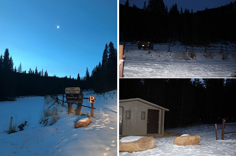
After tucking my kids in for bed I left my house on Sunday night around 8pm and made it to the trailhead earlier than anticipated (3:30am). The dirt road to South Mineral Campground is a 2WD dirt road, well maintained, and at the trailhead has room for about 20-30 vehicles.
Oh, and I’d seen no less than 7 porcupines waddling along the side of the 2WD dirt road in (not all in the same area). Drat: I’d forgotten my moth balls. Oh well, I’d have to cross my fingers this time. The moon was absent but the night sky was filled with millions of stars. I’d arrived early and because I wanted a good look at the basin in the daylight I decided to try and get in an hour nap before starting my hike. I was surprised at how well this worked. I closed my eyes and what seemed like a minute later my alarm rang, indicating it was time to get moving.
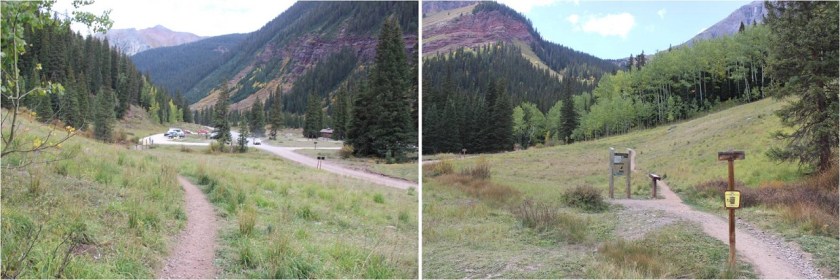
The trail starts on the west end of the parking lot. There’s a trail register to sign before heading out (one of the nicest and well kept registers I’ve ever seen at a trailhead). I started at 4:40am.
I took the Ice Lake Basin Approach, which is a very well maintained trail that crosses a small stream and switchbacks west. It looks like there’s been some recent trail overhaul and maintenance in the area, and even a shifting of much of the trail west, with lots of dead trees/branches covering the old trail. I was unable to find the 4WD parking area that’s been suggested as a possibility for shortening the hike in (I’ve also seen beta indicating this 4WD lot has been destroyed with “no parking” signs in the area now).
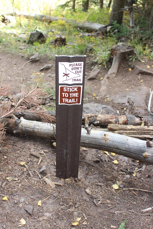
There were dozens of signs asking hikers not to cut trails.
The trail was easy to follow all the way to the Ice Lakes Basin, gaining in elevation steadily.
I made it to the Ice Lakes basin while the sun was beginning to rise.
Ice Lakes Basin:
Instead of stopping at Ice Lake I took a quick picture from the trail and turned south and hiked to Fuller Lake. I wanted to see the lake and old cabin. Had I realized how blue those lakes were when I first passed them I’d have taken the time to explore more, but in the early morning light they weren’t yet impressive.
There was a trail the entire way to Fuller Lake.
What I wasn’t prepared for were the amazing reflections of the mountains on the water as the sun rose. Pictures do not do this area justice!
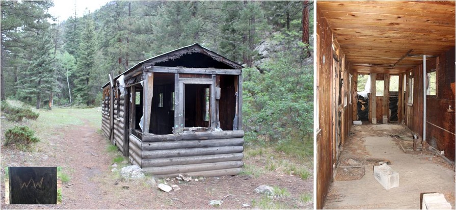
Unfortunately, the cabin has been destroyed, most likely by weather.
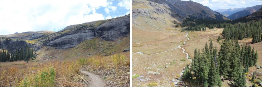
From here there was no trail for the rest of the hike. I could see Fuller Peak to the southeast, and hiked without a trail through the basin towards the saddle of Fuller and Vermilion.
Along the way I saw an old wheelbarrow. Of course this meant a picture was necessary
Here’s the route I took up to the saddle and over to Fuller Peak and a look back down the basin and the way I hiked in as seen from the saddle.
It’s steeper than it looks, and I was glad I was doing this part of the hike before the sun was too high in the sky. The rocks are semi loose talus. Annoying is what they are…
From the saddle turn left (southeast) and follow the ridge to the summit. It’s an easy class 2 hike with several small false summits.
The only downside was I was hiking directly towards the rising sun. It made seeing anything clearly impossible.
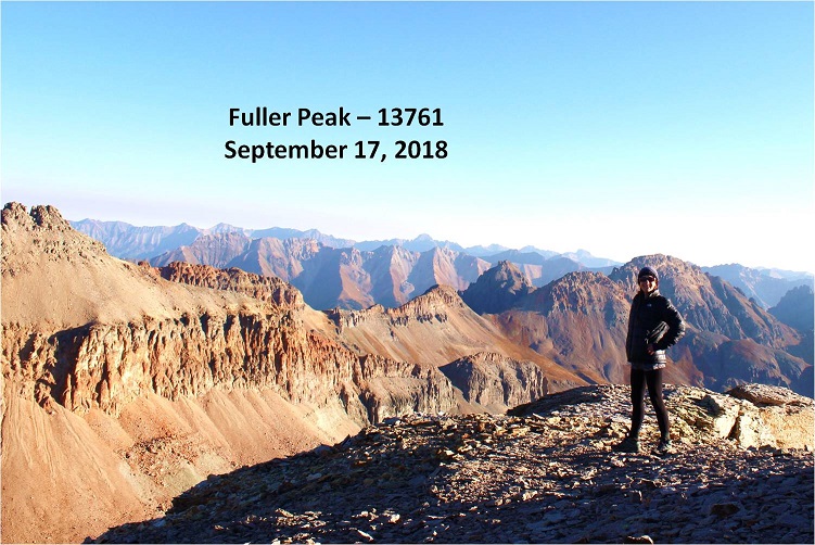
I made it to the summit of Fuller Peak at 8am
Fuller Peak:
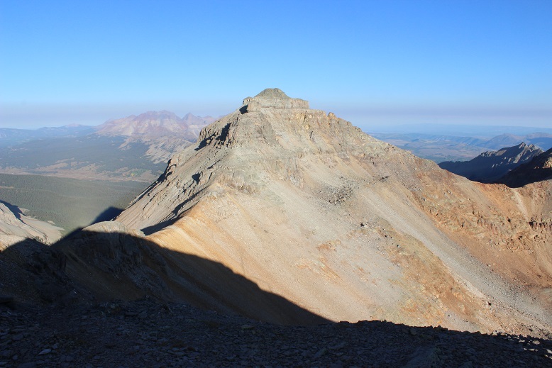
The views were amazing! I looked back at Vermilion and the route I needed to take to the summit. After returning to the Fuller/Vermilion saddle stick to the ridge
Here’s a view of the route from the saddle. Follow the ridge up and to the left
After you go left you’ll encounter a loose dirt gully. Climb the gully to the notch
At the top of the gully you’ll see two towers. Pass them to the left
And climb another gully
The gullies here seem to go down forever! (don’t worry, this isn’t the one I climbed, but one I wouldn’t want to fall down)
From here follow the rocks to the summit
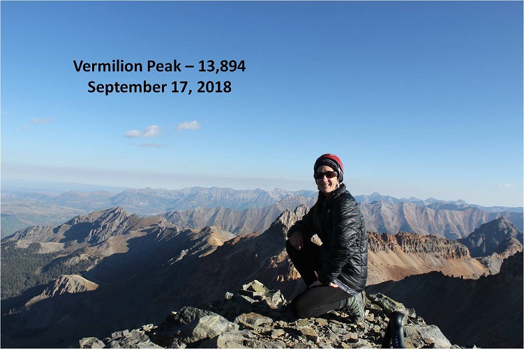
I summited at 8:45am
Vermilion:
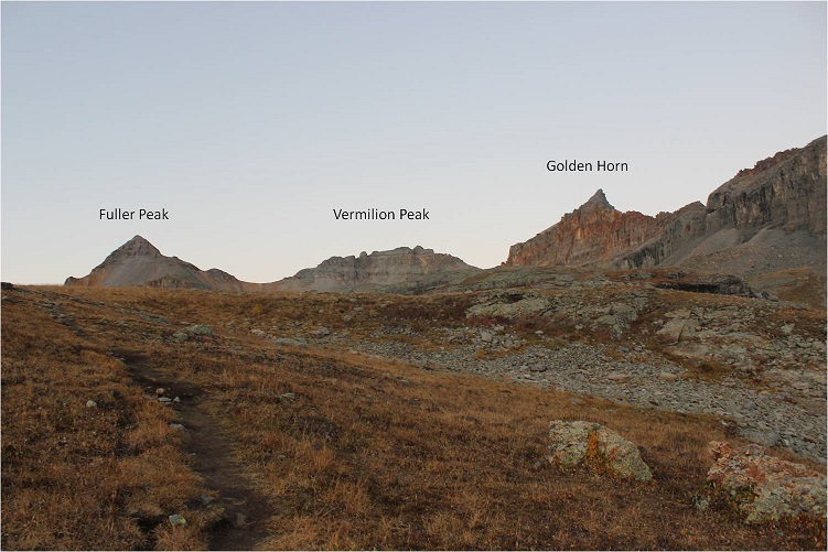
My next task was Golden Horn. I returned to the Fuller/Vermilion saddle and traversed the area on the northeast side of Vermilion between the cliffs and a scree ledge towards the Vermilion/Golden Horn Saddle. You’ll need to descend lower than you think you will. Follow this route (as seen from Fuller)
The scree & talus ledge is wider than it looks, with some large boulders thrown in. The rocks aren’t loose. Here’s a picture looking back from the Vermilion/Golden Horn Saddle
Here’s a look at the route from the saddle.
It’s a pretty straightforward climb, but about halfway up the ridge is when things get spicy. The scree intensifies and it can be difficult to find good footing. Luckily there’s not much exposure.
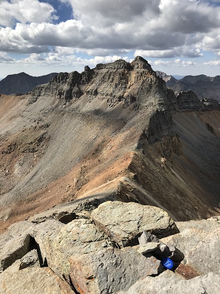
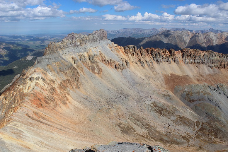
There aren’t any cairns but the route is obvious. There are two summits to Golden Horn. The summit register is on the summit to the west. Here’s a picture looking back at Vermilion
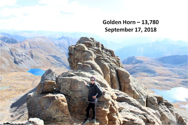
I summited at 10:15am
Golden Horn:
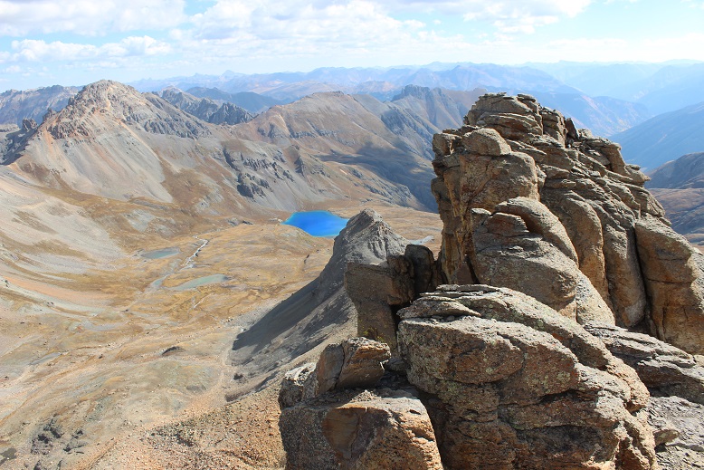
The views were amazing! I could see Ice Lake for the first time in the daylight and was immediately impressed: I had to make it down there!
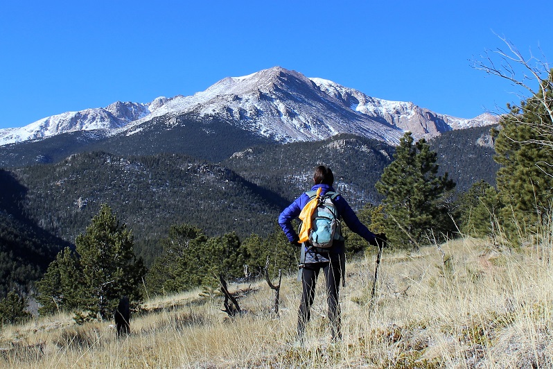
My day had been going pretty good so far. It was still morning and I had the rest of the day ahead of me. The only thing that was troubling was the clouds creeping in. It was supposed to be sunny all day. There were way too many clouds for this forecast to be accurate. I had to keep an eye on the weather. I turned and looked northwest: Pilot Knob.
Hmmmm. It looked tempting. The only reservation I had (besides the weather) was beta. I had great information on Fuller, Vermilion, and Golden Horn, but there just wasn’t a lot of data out there on Pilot Knob. At least not much recent data. While planning this hike I’d been short on time and only planned on the three peaks I’d already summited. I mulled it over: I’d done some preliminary research on Pilot Knob (in fact, I’ve done enough on all the bicentennials to know which questions to ask, when I’d like to summit them, which routes I want to take, etc.). I knew I was supposed to summit Pilot Knob from the south and west face, looking for a chimney that would lead to a scramble to the ridge, and there was a crux I really wanted to get a first hand look at (a crack traverse/climb near the summit). Even though you summit from the south the approach is usually to the north (and I was south).
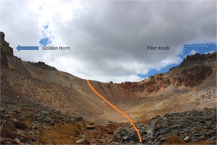
Trip reports last time I checked were few and far between, with the newest being 3 years old. The best beta was years before that. You were supposed to approach from the north and traverse southwest before summiting from the south/west, and I was on the south. I figured I could probably summit today, so I decided to descend Golden Horn the way I’d come by heading back to the Vermilion/Golden Horn saddle and look for a route over to Pilot Knob.
From the saddle I traversed west to the Golden Horn/Pilot Knob saddle.
The first part (before getting to the saddle) was a fun, difficult class 2 scramble. It was the most intense scrambling of the day so far. If you stick to the ridge you’ll do fine.
Here’s a look from the Golden Horn/Pilot Knob saddle, looking up at Pilot Knob
I kept watching those clouds. They were starting to bug me, blowing in and around with what looked like deep blue, rain filled centers. I made it up the ridge of Pilot Knob, and navigated to the southwest to look for a chimney that would lead me towards the summit. Instead I quickly encountered a very loose and scary talus filled gully.
It was obvious several large rock slides have occurred in the area since the last trip report. Many previous trip reports indicated a “well cairned route”. I didn’t see a single cairn, but there had been so many slides in the area they could have been destroyed by one. OK, back to the loose talus. This was unlike anything I’ve ever seen: I’d step on it and a 5 foot wide avalanche of rock would give way, tumbling down below me and gaining speed and larger boulders as it went. The first time it happened it startled me. Two steps later when it happened again I was seriously scared I was going to fall with it and braced myself: unfortunately there was nothing to grab onto.
I knew there was no way I could safely traverse any further west, but I needed to in order to find that rock wall. OK, so this wasn’t going to happen. Maybe I’d accidentally missed the rock wall I was supposed to climb? I’d just turn back and try again. It took me quite a while to backtrack to where I’d started on the south side of Pilot Knob: I was seriously scared I’d fall in an avalanche of talus with every step, but I made it back and decided to try again, thinking to myself traversing the area would be achievable and much safer in winter/spring with consolidated snow and crampons rather than all this talus/scree.
I just needed to gain the ridge. There had to be more than one way? I spent about an hour and a half trying to climb every area I could, but none of the routes I took went all the way to the top, and these were not class 3 moves as described in previous trip reports. They were class 4+ on loose and crumbling rock. Every time I found what looked like a solid route rocks would flake off both above and below me: Rocks the side of softballs and some the size of microwaves. I’d make it 20 feet up the side of a “wall” only to have to turn back and head back down. Rope wouldn’t have helped because none of the towers were stable enough to support a climber that way. I was glad I was the only one out there today.
I’m stubborn, so I did this fruitless climbing up and down walls for much longer than I should have and took more risks than I’m willing to admit to my mom. I even went over to the east side and tried that way. Nope, there wasn’t a way to gain the ridge from either side, and I couldn’t descend the slope and try to make my way to the north side to summit that way (it cliffed out). I was super frustrated. Hmph. I had to remind myself Pilot Knob wasn’t even on my list of climbs for today so I shouldn’t be too disappointed. But I was. I mean, I had hours left of daylight (it was only noon) and I really wanted this summit.
Wait! I know, I’ll just descend into the basin and re-gain the saddle from the north side, traverse southwest and try it that way! I was positive the right rock wall was on the other side of that talus/avalanche gully I couldn’t traverse. I made my way back to the saddle and looked at the route I wanted to take. Here’s a picture of that route from Golden Horn.
I looked up at the clouds, and it was obvious I was going to have to turn back. There wasn’t enough time to descend into the basin and re-ascend to try and summit. Oh well, I need US Grant too. I’d just combine the two the next time I was out here.
I made it back to the saddle and headed down into the basin. Here’s a look back at the route I took
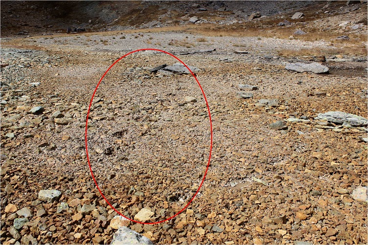
I felt I was getting pretty good at this descending down a scree slope into a basin thing. As I was hiking down I thought to myself how the area looked like it usually held water. It was made up of tiny flat rocks about the size of a silver dollar but an inch thick. The kind you’d usually see on the bottom of a lake or pond. Hmmm. I guess since it was such a dry year there wasn’t any water. I was walking on a lake/pond bed. And it was squishy. In fact, walking across it felt just like walking over a bog. No sooner had this thought entered my mind than realization hit and it happened: I heard a sucking sound as my left foot sunk into the muck up past my ankle (mind you, I was walking on rocks at the time) and was almost impossible to dislodge my foot.
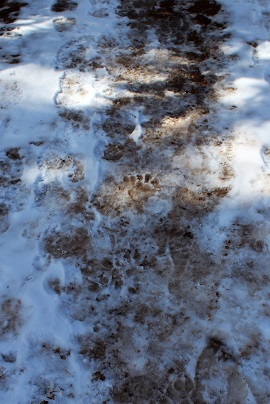
No. No. No, no, no! I know how to get myself out of a bog/quicksand if I have to, but I really didn’t want to end up covered head to toe in mud (I was camping tonight after all and wouldn’t see a shower anytime soon). So I dislodged my left foot and ran as fast as I could, kicking up my heels as I went, trying to escape the mud that was trying to pull me under with each step. All in all it wasn’t that bad: with the running I only sunk up to my ankles, but I could tell if my foot had rested in any one place I’d have sunk much further as the mud had great suctioning abilities. Then I’d really be stuck. I made it to stable ground and let out a sigh. Crisis averted! My shoes and pants were caked in mud, but that was the worst of it. Here are my footprints looking back
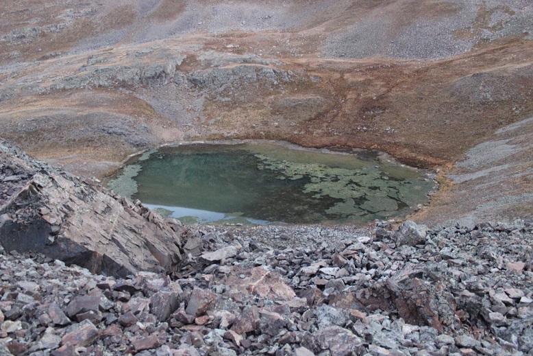
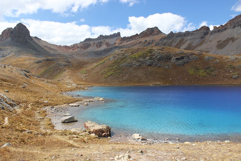
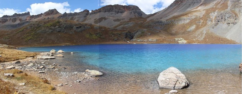
I turned east and was greeted with a daytime view of Ice Lake. Wow! This was beautiful!
As I got closer I could see how truly clear the water was.
Ice Lakes:
This was amazing! I stopped for a while, took a bunch of pictures, and then headed on my way back down the basin where I was greeted with aspens changing color. I’d missed them on the way in when it was dark.
There were tons of people on this trail! I must have passed dozens (and it’s a Monday). It was a long 4 miles back down. I made it back to my truck at 2pm. And it never did rain. Oh well, this gave me time to find my next trailhead in the daylight. I took off my muddy pants, socks, and shoes and put on my sandals for the drive. Near the 550 on the road out I got cell service and stopped by the side of the road for a bit to do some work (emails, etc) and text my kids to let them know I was down the mountain and headed to the next.
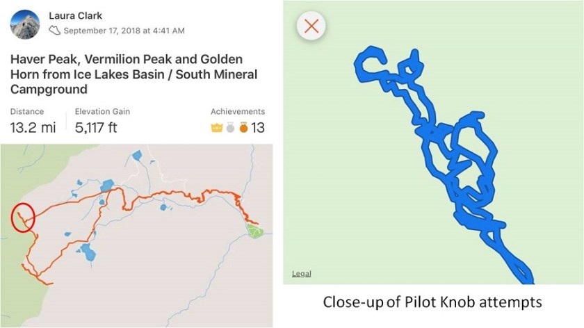
Here’s my route with a close-up of my Pilot Knob attempts. Don’t worry, I’ll be back for this one!
My drive took me through Silverton. I’d heard the fall colors weren’t supposed to peak here for another 2 weeks, but right now it looks beautiful.
I had conflicting directions on how to get to the Burns-Gulch trailhead, so I brought both with me. From Silverton I took County Road 2 past Eureka on a 2WD dirt road, and ate the dust from off road vehicles the entire way. For a Monday afternoon it sure was crowded! Leaf peeping season is definitely in full swing!
I made it to the base of the trailhead on the Animas River and my directions ended. So I pulled up a GPX file of the route to see where I needed to be: about 2 miles up a narrow shelf road.
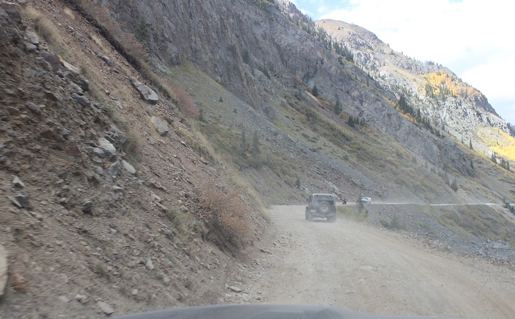
The road was much narrower and steeper than it looks and filled with bowling ball sized rocks. I took it slow: this road was more difficult than I’d anticipated (but nothing my truck couldn’t handle). I just hoped no one would drive towards me from the top: There was no way I could turn this truck around on such a narrow road, and passing another vehicle wouldn’t be easy.
There was a campsite at the 4WD trailhead at 11,720’ and no other vehicle was in sight. Sweet! It looked like I was going to have the site all to myself for the night.
I got to work making dinner: Mountain House Beef Stroganoff. When it was ready I poured myself a glass of wine in the measuring cup I brought for making dinner, sat back, and enjoyed the view.
Life is good! Sitting in the bed of my truck looking at the mountains was so relaxing. As I was sitting there I heard a creek to my right and got up to investigate. This was wonderful! It was about 10 yards from where I’d parked my truck. I enthusiastically washed my hands in the running water. They were gross from today’s adventure and it felt good to have clean hands and fingernails again. I got up to turn around and head back when my left sandal broke. I mean really broke, like duct tape can’t fix it broke. Drat! I was going to have to tiptoe the 10 yards back to my truck without wearing shoes. The first step I took landed my left foot on a thistle. Wonderful. I made it back to my truck, poured myself another glass of wine and spent the next half hour picking splinters out of my foot (mostly on the heel and arch). I looked around at the mountains: Life was still good!
I got out my maps and route info for the next day and tried to identify the peaks around me and the best route to take (I had several options). I studied my chosen route until I felt it was time to get some sleep: it was starting to get cold.
I decided to sleep in the cab of my truck because I fit perfectly across the back seat and because I could. Two shots of whiskey later I was ready to go to sleep. I laid my head on my pillow and a fly landed on my arm. I thought about how much fun having a fly buzzing around me while I was trying to sleep would be and debated whether or not to open the door to let it out. In the end I decided I’d rather not let all the warm air out in doing so, so I made a deal with the fly: “Fred “(I named him Fred)”If you promise not to buzz around me all night I promise not to kill you right now”. Fred flew away to relax on my steering wheel and I fell asleep thinking this wasn’t a bad way to spend my last day of being 37.
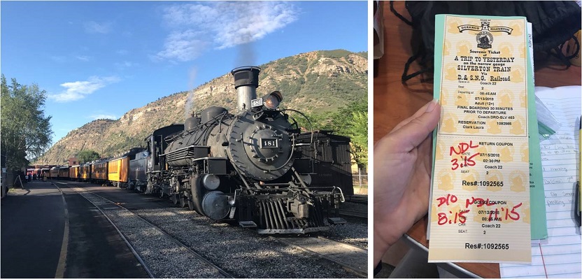
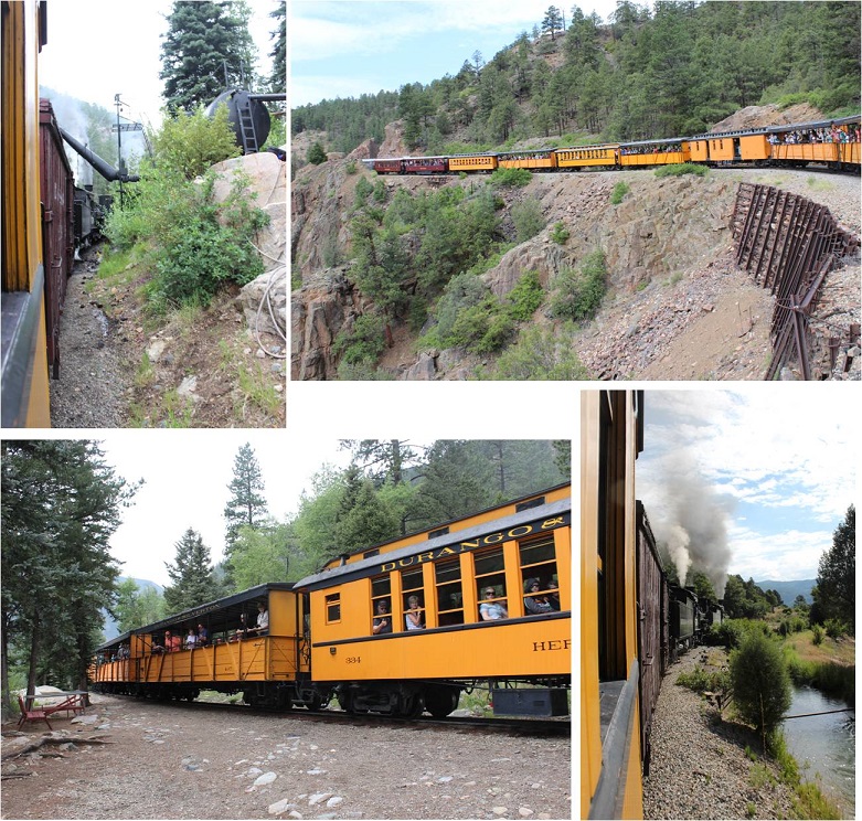
I’ve been preparing for this weekend since February when the summer camp catalog came out. I knew I wanted to plan this trip for the days when my youngest daughter was at summer camp, so when she chose her camp I made my reservations with the Durango & Silverton Narrow Gauge Railroad for the days she’d be gone.
It didn’t matter what the weather was, that was the time I had available to go. My son was going on a solo road trip to Arizona (well, he brought the cat) and my oldest would be at Drums Along the Rockies, so I had 1 free weekend to backpack this summer.
Well, then the fires happened and not only did they shut down the railroad, they closed the entire San Juan National Forest. This was unfortunate for numerous reasons, and also because it looked like my trip wasn’t going to happen. Then they re-opened the forest (woot!) but not the railroad. This was getting frustrating! I kept calling the railroad station to see if they were going to be running the train, and every time I called I got a different answer.
So I made two plans: One for if the train was running, and another for if it was not. This was my one weekend to visit the Chicago Basin and attempt its 14ers this summer and I didn’t want to waste it. Going through Purgatory didn’t sound fun but if it was my only option I was prepared to hike into Chicago Basin that way. Normally I wouldn’t mind, but I had a strict time limit because I had to work Monday morning.
I checked and re-checked and checked the weather forecast again. It did not look promising. 70% chance of thunderstorms in the morning, afternoon, and evenings for the entire weekend. These conditions were less than ideal but at least I could prepare for them. I became a weather expert (it seems this isn’t monsoon season yet, but pre-monsoon season that mirrors the actual monsoon season… yeah, basically it’s going to rain buckets with lightning and thunder added in for fun, and it won’t be predictable).
I packed, unpacked, reduced, and packed again. I decided to cut weight by eliminating the need to cook my food (I make a mean beef jerky and dehydrate fruit to bring with me that doesn’t need to be cooked) and added warm layers. Extra socks, pullovers, hats, and gloves.
The day before my trip the train was scheduled to run again, but they weren’t giving out backcountry permits until late August. However, they would honor my tickets since I’d bought them so long ago. Woohoo! I was good to go!
Thursday afternoon I closely watched the weather out the windshield of my truck as I drove the 6.5 hours to Durango. If the weather tomorrow was like today I was golden: heavy cloud cover with no rain. Before checking into the motel I stopped by the train station to pick up my ticket. There was only one other backcountry permit in the queue besides mine, which told me not many of us would be packing in with the train.
Next I checked into the motel. I made small talk with the man at the front desk wearing the Zia Marching Festival shirt (my kids went two years ago for band so small talk was easy) and was assigned a room and a parking space. I stopped by Wendy’s for a quick dinner and brought it back to my room.
This was the smallest motel room I’ve ever stayed in, mainly because I’m a hotel snob. I travel a lot for work, and I need the hotel to have a gym so I can work out every morning. Most hotels with gyms are just… nicer in general. I didn’t think that was necessary for tonight’s stay, so I just chose the cheapest place I could find. I had an assigned parking space my truck didn’t fit into and a room just big enough to walk around the bed. I was a little concerned my truck would get broken into overnight. Well, all I really needed was a place to sleep, so this would do just fine. Check out the view from my room…
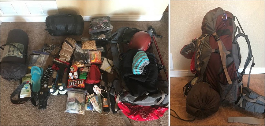
I poured myself a glass of wine and brought my backpack in from the truck. After dumping all the contents on the bed I went through my gear one last time. I’ve been backpacking many times, but tonight I seriously felt like Cheryl Strayed. I dipped a fry into my frosty and considered: I’d done a good job packing. There was nothing I thought I didn’t need and I had extra space in my pack. Everything was in a Ziplock bag and I had extra large trash bags if needed. I was good to go! But it felt weird only packing for myself. I haven’t been solo backpacking in a long time: I’m usually in charge of a group of scouts, so I have to over pack things like emergency supplies, food, etc. I could get used to this!
I took a last minute shower (I’d brought my Disney shampoo for good luck: if you’ve ever stayed at one of their resorts you know what I’m talking about), and charged my cell phone and camera. I made a list of goals for this weekend (stay warm/safe/make good choices, learn something, make the most of the time I had, hike at night if necessary, and if the weather’s bad sleep until it’s good). I did some texting and problem solving and answered some very important last minute emails that came in about a potential magazine interview on Monday and made it an early night so I could get started early in the morning.
I had a couple of people who had considered hiking in with me but had canceled due to weather. I was actually relieved they weren’t able to make it! I would have been a terrible hiking buddy in this weather because I’m too goal oriented and I don’t need much sleep. Hiking solo gave me time to hike as fast as I needed, set up camp (or not) and hike/eat/etc. whenever it worked for me. If someone else had been with me I’d have felt responsible for their comfort/ etc. and I’m pretty sure I’d have either made them mad or I wouldn’t have summited (making me mad).
The night had been sweltering. There was an air conditioner that I had to turn off because all it did was make noise. Well, you get what you pay for. I had to take another shower in the morning because it had been so hot overnight. I dressed for success in my new hiking pants that are supposed to repel insects and are two inches too short because I had to get them in the kids section. (Note to athletic/outdoor clothing manufacturers: not every “woman” is large. I’d like some hiking pants that fit a 5’4” 105lb woman please… I’ve been looking for years and resorting to wearing yoga pants under your size 2’s or shopping in the kids section isn’t working for me!)
I did one last sweep of texts and put my phone on airplane mode. The weekend had officially begun.
Check out at the motel wasn’t until 8am but I had a train to catch. The front doors were locked so I dropped off my room key in the slot and headed to the train station. It was a beautiful morning! And that sunrise! It almost physically hurt not to be hiking now when the weather was good.
I was the first one of the day in the parking lot at the train station. I parked in long term parking with 3 other vehicles from yesterday and mentally calculated how many people should be in the basin.
McDonalds was close so that was breakfast. I haven’t eaten this much fast food in quite a while. In fact, I don’t think I’ve been to a McDonald’s since I was in High School. Thoughts from the McDonald’s lobby: it smells like cigarette smoke in here, there are two types of people here: those in their pajamas and those in their motorcycle gear. The parking lot filled up fast.
My Daily Daisy text pinged my phone and I took it as a good sign:
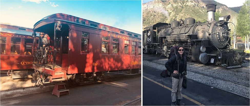
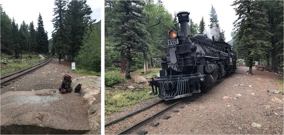
I went back to my truck to get my gear and walked to the train station.
Of course I got there early, so I walked the platform and talked to the volunteers and employees. They were all thrilled to be working again, as they’d all been out of a job for the past 6 weeks. Some teared up as they talked answered questions.
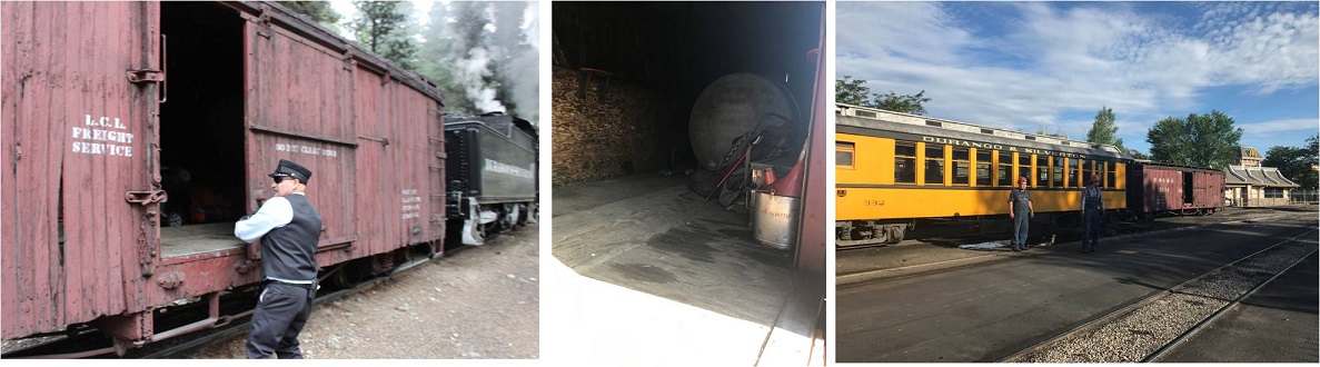
With the help of brakeman Chris I loaded my gear into a boxcar with the two other backpackers and thought to myself how it was already hot outside and I stunk. Those two guys in the picture below on the right stayed behind and watched the wheels on the train to make sure there weren’t any sparks. Several employees shook hands with the engineer and told him to “stay safe out there”.
The train left right on schedule. There were homemade signs and posters all over the fences thanking firefighters and welcoming the train back. Several houses had “Welcome Back Train” signs, and tons of people stood by and cheered the train on as it left, or came out to see the train as it passed by their front yards. The citizens were visibly emotional to see the train in action again, wiping away tears sand clapping. You could tell the closure of the train had impacted the community greatly.
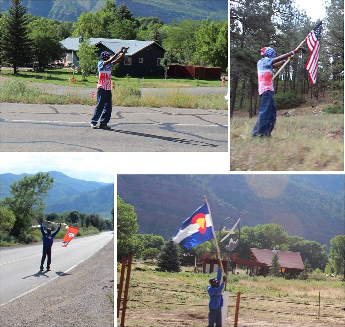
Check this guy out! We saw him every few miles or so, cheering us on. I’m not sure if he was an enthusiastic Durango citizen or paid to do so by the train station, but he would cheer us on, get in his vehicle and drive ahead of the train, change is outfit, and get out and cheer us on again. Everyone on the train loved him. We passed him at least 8 times.
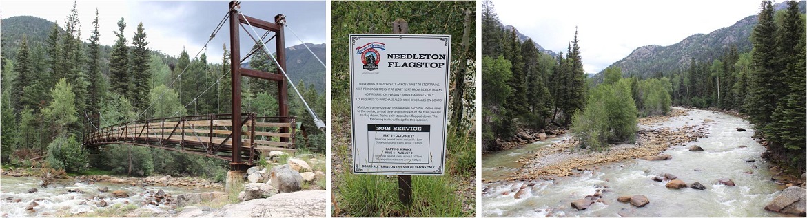
I sat next to a brave mother and father of 6 well behaved boys under 10 years old. One of the train employees talked with me about stopping in Needleton and asked me if I knew how to jump off of a moving train. The boys eyes got wide when I said “Absolutely, I just tuck and roll, right?”
It was a long 2.5 hours to the Needleton stop. I passed the time by going over my trail notes again and again. I arrived at the Needleton flagstop at 11:40am.
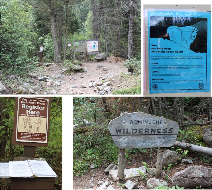
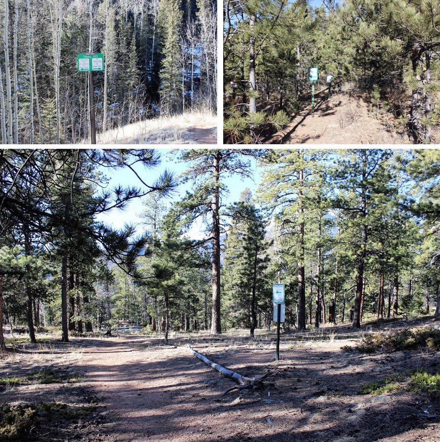
I waved goodbye to the train, said a quick greeting to the other two hikers, and started the 6 mile hike to the Chicago Basin. This hike has excellent signage. I signed in at the trail register at about .8 of a mile up the trail where it intersects with the Purgatory Trail.
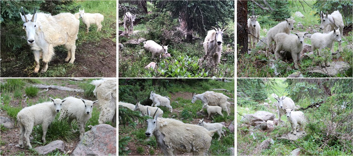
I passed several groups of hikers hiking out as I was hiking up. They gave me some advice that ended up being very useful: Hang everything up when you leave with your bear bag. Leave nothing in your tent or on the ground. The goats and marmots will eat through your tent to get to your stuff. Also, don’t pee anywhere near your campsite: the goats like pee and will follow you to get it. I found this last part weird since usually urine (especially male urine) usually keeps predators away, but I guess goats aren’t predators and like the salt. In any event, their advice was correct.
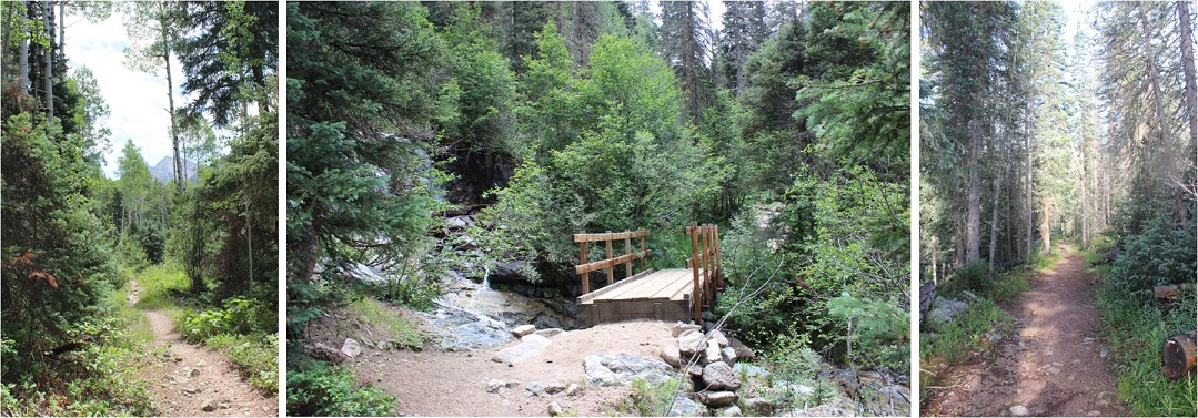
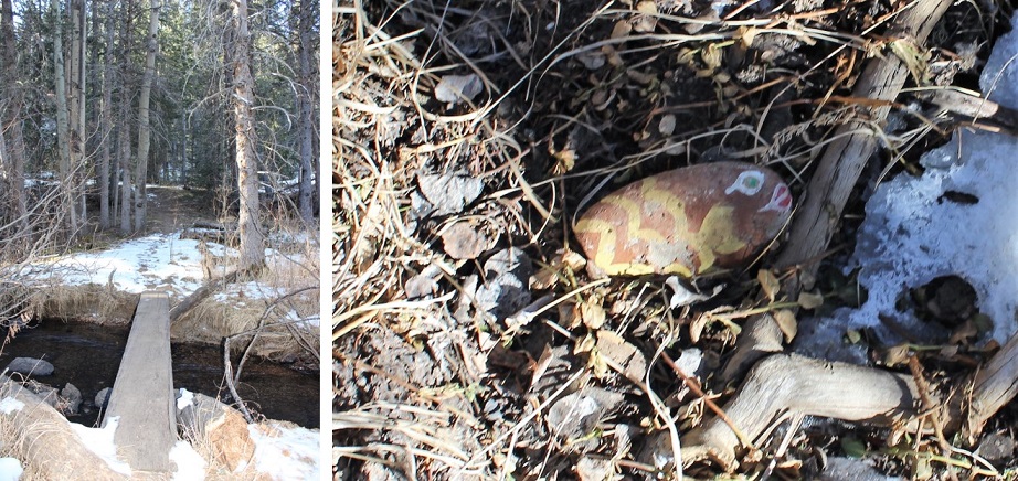
The trail was heavily shaded and followed a creek, but that didn’t stop it from being hot out! I don’t usually hike in the middle of the day: It’s tiring! Most of the hike in follows a creek. At the halfway point I crossed a bridge, knowing I had 3 miles left of the hike and seriously hoping it would rain soon.
There were tons of strawberries covering the ground, as well as downed trees. When I saw this small waterfall I stopped and dipped my head in the water (swallowing some in the process, so if I get Giardia I’ll know why). This cooled me off and felt amazing! I soaked my bandana and continued on. From here it was 1 mile left to the basin.
I arrived at 2:40am and was greeted by tons of bold and very adorable goats! Here’s proof:
The goats were everywhere, and seemed to like my company. I carefully placed a beer in the creek to cool off, set up camp, hung my bear bag, re-hung my bear bag because the first place I hung it was covered in sap, and looked up at the weather. It didn’t look too promising, so I went back to the creek to retrieve my beer and went back to camp to eat something. I’d been saving the beer for tomorrow but I was really hot and needed to cool off. I sat down to eat and it immediately began to hail!
This lasted for about 45 minutes and cooled everything off in the basin. It was a good time for me to eat, rest, and get my bearings. There were a lot of people camping in the basin, many more than I’d anticipated considering they couldn’t take the train. They must have all hiked in from Purgatory. Oh, and the inside of my tent was getting wet. Lovely. It stopped raining at 5:15pm and just before it completely stopped I decided I wasn’t going to waste any time. I hung up everything I wasn’t taking with me, gathered my gear and headed towards the trail.
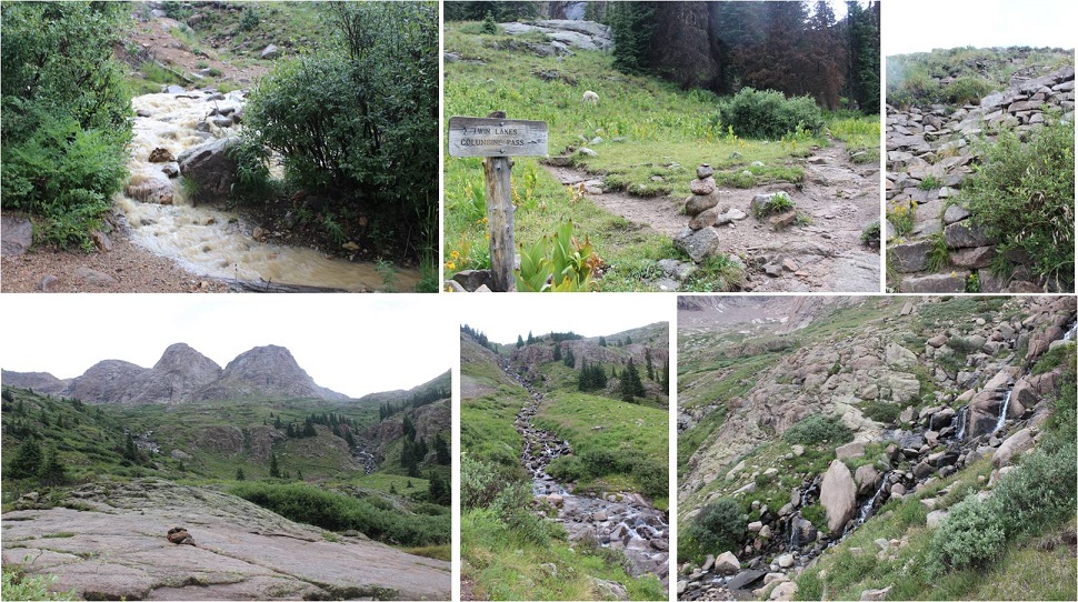
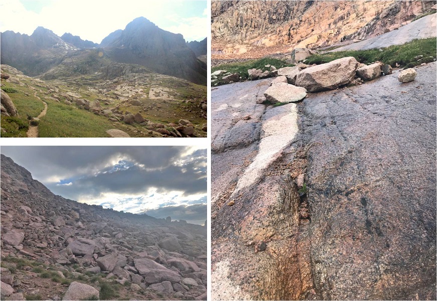
The Twin Lakes Trail gets you to the intersection for all 4 14ers, so I decided to hike up to Twin Lakes and make my decision then which 14er I’d attempt tonight once I got there. I passed several goats along the way.
Since it had just rained/hailed the creek crossings were high. I had to get creative to cross them. The trail came to a junction where I turned left and followed it up the hill, through some rocky areas and some well maintained stairs up a slope and through some waterfalls.
At the top of the slope was Twin Lakes. I could go either left towards Mt Eolus and North Eolus, or right towards Sunlight or Windom.
I’d been doing a lot of thinking on the trek up to Twin Lakes about which 14er I should attempt. I really wanted to get both Eolus and N Eolus done tonight, but as I was watching the weather it looked best near Sunlight Peak. It was a difficult choice, but I chose Sunlight, purely due to weather. I mean, doesn’t it look inviting?
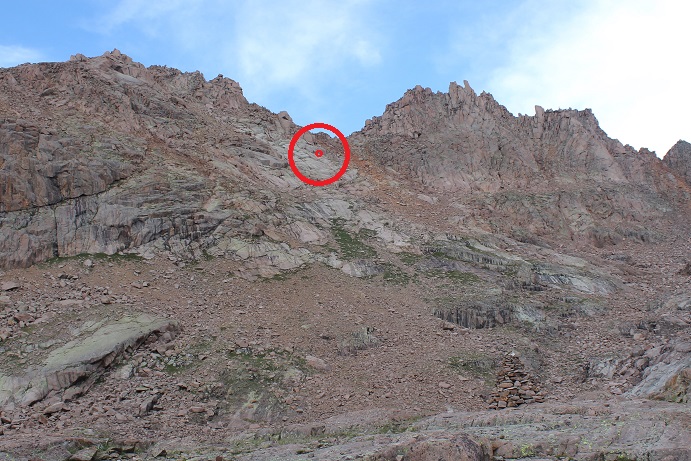
Here’s the route I took:
As you can see, the route is very well cairned. I followed the 6 foot tall cairns toward the gully, and then up the gully to a notch. This gully was a good gully! It had some loose terrain, but was mostly made up of rocks about the size of a tire. I was keeping an eye on the weather, but as you can see, it looks great!
From here I followed the route left. This part was actually quite easy and didn’t require much route finding, just some scrambling over class 3 terrain.
Here’s a great view from a hole in the ridge. I decided not to take this route but to turn left and head to the final summit pitch.
From here there were a couple of class 3 moves, and then a class 4 move up and around to the summit. I made it to the summit and decided to drop my gear and climb the last bit to the “true summit”. It was a scramble on some grippy rock to the top of a few boulders placed a few feet apart in all the critical areas. That had been too easy!
I made it up to the top of the highest boulder and took a look around. Wow! I needed a picture of this! Drat! My camera was back down with my stuff. No worries, I’d just climb back down and get it. I slid feet first down the rock and jumped onto more solid ground. I got a few pictures of the summit marker and surrounding peaks
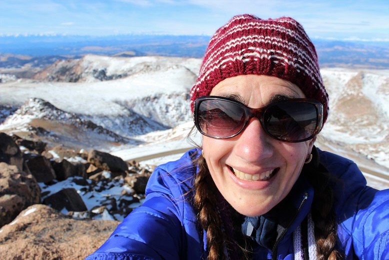
And took a summit selfie to prove I’d summited.
I took a quick video of the summit, and came to the realization a storm was approaching very quickly. I hadn’t been able to see it from the way I’d climbed in, but it was obvious now I needed to get back to treeline as soon as possible.
Please watch the video below with the sound on. Note it starts at 7:58pm, and then it jumps to 8:30pm.
In 10 minutes time I made it to the top of the gully and it started sprinkling. Wow, that was fast. No worries, I’d just put on my poncho and keep heading down. I made it about a quarter of the way down the gully when the sky broke loose: it started pounding rain, and then hail, and then the thunder and lightning started. There was nowhere to hide: No caves or rocks to hide in or under. I was completely exposed and I couldn’t hike up or down to find shelter, as there wasn’t any. I didn’t want to be a moving target so I found two large rock slabs that didn’t provide any shelter to back up and huddle against. I still had my helmet on, but water was cascading down the rocks straight onto my head, and I was being pelted from the front by the storm. The second half of this video takes place after the worst of the storm is over, but you can still get a sense for the atmosphere.
Just for reference, this is where I was during the storm.
I sat there for over an hour and a half, listening to the thunder crackle all around me and waiting for the lightning to stop. There was no lightning tingle or electric current in the air as I’ve heard from other people who’ve been caught out in storms. Luckily most of the lightning stayed in the clouds, but every so often I’d see a bolt strike Windom. I couldn’t get off that mountain fast enough, but I needed to be safe at the same time, so I waited it out. When I finally felt the lightning was far enough away I got out my flashlight and hiked back to the Chicago Basin soaking wet.
Well, as far as picking a peak to hike tonight I had picked the right one. Windom was a nightmare with all that lightning, and I realized the next day I wouldn’t have been able to summit the other two peaks: I’d have had to come back and hike at least one if not both of them again the next day.
I made it back to my campsite sometime before midnight, and the entire basin was already asleep (besides the goats I said hi to as I passed them on the trail). I was hungry, so I brought down my bear bag and rummaged around for something to eat. Peanut Butter sounded good, but where was my spoon? In the dark it was difficult to find anything, and I was trying to be respectful and quiet for the other campers. Well, I couldn’t find a spoon, but I did have some dehydrated bananas that I could use as a spoon. So there I squatted next to my bear bag, trying not to sit on the ground because it was wet, flashlight on the soil, with a tub of peanut butter in one hand, and the other scooping it out with a banana slice. When I was done I licked my fingers and put everything away.
Now to deal with my sleeping arrangements. I’d put my sleeping bag in the tree with my bear bag before leaving to keep it away from the critters, not anticipating the rain, and now I had a soaked sleeping bag (or so I thought). Luckily I’d brought two tarps. One I’d put under my tent earlier today when setting up, the other I got out now and as quietly as I could folded into a square and placed it inside my wet tent, forming a barrier between the wet floor and myself. I opened my sleeping bag and was delighted to find the fleece blanket I’d rolled around the sleeping bag had absorbed 95% of the rain water, and the sleeping bag itself was mainly dry. I hung the fleece outside and settled down for bed.
Saturday morning came early. After almost 4 hours of sleep I was up at 3:45am and out by 4:15, ready to tackle another peak. I re-hung all my gear by my bear bag and set out in the dark, hiking under the stars and some wispy clouds. The clouds didn’t look too threatening. Everything was still wet from the storm.
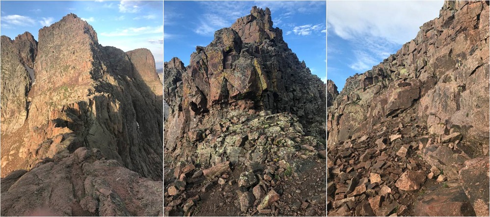
I followed the same route I had yesterday up to Twin Lakes. My legs were still sore and I was actually thirsty. I hiked slow and steady past Twin Lakes and towards Mt. Elous. Here the sun began to rise and I got a good look at the route before me.
I hiked towards the edge of a basin and then up a ramp and over some rock slabs
Here’s where the hiking got fun! It became a climb from here on out. I climbed up this optional (class 4?) wall to reach the saddle / ridge
And looked at the catwalk to my left. This was going to be fun!
There was a lot of exposure here but the route wasn’t too narrow. I followed the catwalk to the final pitch up the East Face, which required a lot of route finding and class 3 moves. Let’s just say aim up: There are tons of cairns and they all parallel each other, but the basic route goes up.
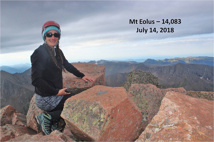
Woohoo! Summit Selfie
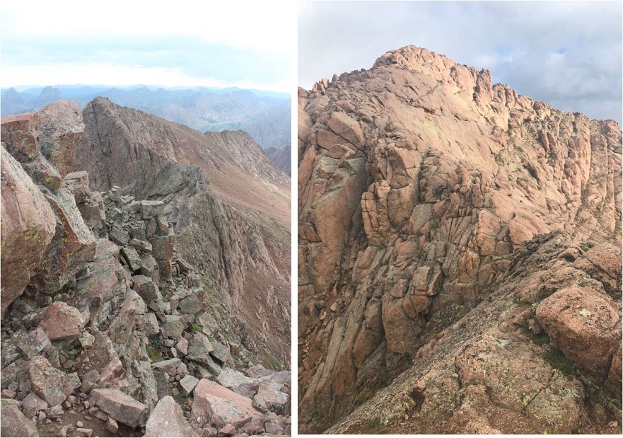
Now it was time to head back and tackle North Elous. Here’s a look back at the Catwalk and North Elous’ Ridge
The ridge was actually very easy to navigate. It had grippy rock and was a sticky but simple scramble towards the top. Once again, I was glad I’d chosen today to hike this instead of yesterday. Oh, and I was a bit sore so I was hiking slow.
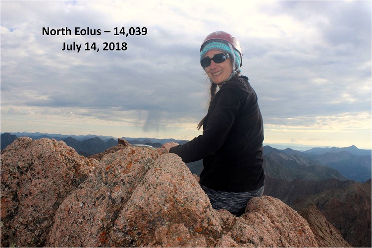
I took a quick summit selfie
And looked back at the way I’d come. Pretty cool! The catwalk looks like a beast, and so does the way back down.
Ok, 3 down, 1 to go. I was closely watching the weather today as I hiked back to Twin Lakes. I made it to the lakes at about 9am and was concerned with the amount of clouds I saw in the sky. I figured I had a 50/50 chance of needing to bail on Windom, but like I said before, I was sore and didn’t want to hike down to Chicago Basin just to hike back up to do Windom again later today: That elevation gain was brutal! I decided to try it, as I could always turn back if needed. I’d just take it slow and keep watching the weather.
At Twin Lakes I met Boy Scout Troop 393 from Phoenix, a fun group of guys to talk with. They were filtering water, and told me about the time a couple of years ago when they hiked Windom. A few of them were Eagle Scouts and Life Scouts.
I continued on towards Windom. The trail follows much of the same route as Sunlight through the basin, but then angles right up a gully (there is a trail to the right near the ridge but it’s currently washed out).
There were several routes, but I took the gully up and aimed towards the ridge, to what I found was a false summit. Drat! I thought I was making great time and I’d been so excited I was going to climb this mountain before the weather set in, but when I hit the notch I realized I still had another 45 minutes or so to go. I steeled myself against the let down and kept climbing, more intent now than ever on finishing this trek.
The final push from the notch follows the left (not the right as the GPS told me to go) and contains some class 3 moves, even though it’s rated 2D. It was very well cairned, and quite a bit of fun!
It took me longer that I’d have liked to summit, but when I did I felt fabulous!
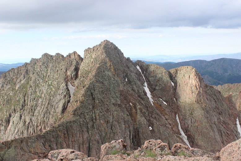
Check out that view of Sunlight!
OK, now it’s time to head back down. The weather was holding, but I didn’t want to cut it close. I turned around and the Boy Scouts called to me from the saddle. They wanted to know if they could summit before the rain hit. Now, that’s a difficult question to answer. I’m not sure how fast they hike, and sure, they could probably make it up, but they weren’t going to make it down before the rain hit. I told them as much and passed them on their way down. They’d already hiked this one a few years ago, so they knew the route. I wished them luck and continued on.
Just before making it to Twin Lakes I met up with the rest of their troop (not all were prepared enough to climb Windom today). We had a nice chat before I excused myself to head back down to camp. I practically skipped back down as the weather held. Sure, I hadn’t brushed my hair in 2 days, I was getting hungry and I was tired, but I’d just summited the 4 14ers I’d come to summit! This mission was a total success!
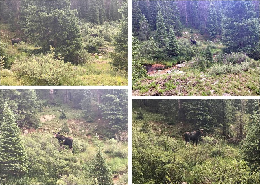
To top it all off, today I did everything right. All my clothes and sleeping bag were dry, as it hadn’t yet rained. I took a trip down to the stream to filter some water and stumbled upon two moose! A male and a female who didn’t much care I was there
I went back to my tent, ate about ¼ a package of Ramen and some dried fruit, and then cleaned myself up before the rain started. My feet were sore and I stunk, but I was happy as I sat all dry in my tent. I thought about tackling Jupiter tonight/tomorrow. Should I? I kept going back and forth with it in my mind. I took a quick 2 hour nap and was woken by my neighbors. Unfortunately they were boisterous and the man’s voice carried. It continued to rain so I decided against Jupiter for now. I lay down, and the next thing I knew I woke up at 1am, needing to use the bathroom. Well, that had been quite a nap! I guess I’d caught up from the night before. The only problem was it was too early to hike. I didn’t want to summit in the dark, so I decided to just lie in bed and wait an hour or two. The next thing I knew it was 5am, and now it was too late to summit and still make it back. Or was it?
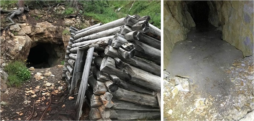
I jumped out of bed, gathered some food, and went to look for the Jupiter trail. As I was hiking I really gave the outing some thought, and while I felt I could summit in time I was worried it would put me hiking back down to the train during the wet weather time of day, and I didn’t much want to do that. So I made a nice 3 mile loop out of the hike instead. I came across an abandoned mine I’d wanted to explore but the ice kept me from it
I stopped for a bit to filter some water, and then continued the trail as it followed a ridge. Here I meet a ton more goats all playing on the scree slope. Two baby goats looked like they were trying to push each other off. The rest just seemed to be rock climbing.
I leisurely walked back to camp, and when I arrived at 7am I was surprised to find the Basin was totally cleared out! Everyone had packed up and left. Wow! So I packed up my things, said goodbye to the goats, searched for and picked up pieces of trash, and left at 7:45am to head back down to the train.
I was in no rush today, which is not normal for me. I’m always in a hurry. I actually stopped, took breaks, and enjoyed the waterfalls and streams. It was so nice not to be in a hurry! I stopped to have a snack by a waterfall, and once I’d made it down to the Needleton/Purgatory Junction I took off my shoes and soaked my feet in the stream as I heard the 11:30am train go by. I washed my hands and re-did my hair. There were tons of flies here, and I tried not to take offense they seemed enamored with me.
I put my shoes back on, passed 4 hikers who’d been let off the train and watched the clouds roll in as I made it to the flagstop. Hey, guess what? I just realized I hadn’t seen a single mosquito this entire trip! I thought the Chicago Basin was notorious for mosquitoes? Hmmm… I must have been lucky!
I made it to the flagstop at 12:30pm, which meant I had 3 hours to wait for the train. That’s quite a bit of time to do nothing, but almost immediately it began to rain. I crossed the tracks and found an old shelter on the other side. It didn’t look too safe, but it did look like it would keep me dry. I’d just have to be careful not to sit down/step on any nails.
For the next 2 hours I watched the rain from inside the shelter. It looked much worse on the trail, and I congratulated myself for not going for Jupiter today: I’d have been stuck in that hailstorm hiking right now if I had.
At about 2:30 the rain stopped, so I went back out by the tracks. A little before 3pm the 2:30 train went by, and out of nowhere 3 high school aged boys ran across the bridge to wave at the train. It seems they’re staying at a cabin on the river (they’d come in by train this morning) and their only entertainment was waving at the train, so they were coming out every time one passed.
My train came closer to 4pm. The two other hikers who’d come in on the train with me were there to take the train back (they’d gotten caught in the hailstorm hiking back down). After getting a $5 beer I had some great conversations with the other people sitting next to me. I tried to relax before my 6 hour drive home, but everyone was chatty. I was ok with that. In fact, I was just fine. I’d accomplished what I’d come to accomplish, meaning I didn’t have to hike in through Purgatory next week to finish hiking the Chicago Basin 14ers. But… I’d still like to come back at a later date, maybe with others next time. I would also still like to come back and do Jupiter someday, but I’m thinking of making it a day hike from Purgatory…
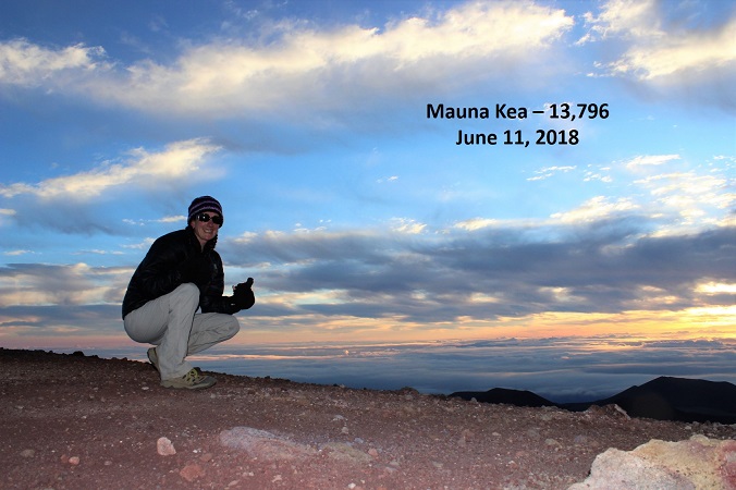
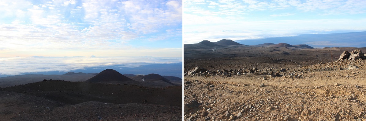
June 11, 2018: This hike has been on my bucket list ever since I discovered it’s the highest mountain on earth when measured from the sea floor. You see, Mountains are generally measured from sea level, in which case Mount Everest (29,028 feet; 8,848 meters) is king. Hawaii’s Mauna Kea, though, rises an astonishing 33,476 feet (10,203 meters) from the depths of the Pacific Ocean floor. Measuring from base to peak, Mauna Kea is the tallest mountain on earth.
We’re here in Hawaii on a family vacation, celebrating my son’s High School Graduation and enlistment in the United States Air Force. My mom and brother tried just about everything to get me not to hike this mountain. They hate that I hike alone, and kept coming up with excuses as to why I wouldn’t be able to go on a solo hike on this trip. (No, they didn’t want to hike with me). You see, we were so busy they just didn’t see how I could schedule it in. I told them I’d make it a sunrise hike (even though I hate those due to hiking in the dark and the cold), meaning I’d be back home no later than 10am, which wouldn’t interfere too much with our day. Well, maybe now we could find time on Tuesday or Wednesday (the only day snow was predicted on the mountain) as those were our late start days.
Then the volcano erupted and changed all our plans. My brother figured the eruption ensured I wouldn’t be able to hike, and let met me know the National Park was closed (our plan for Monday and Tuesday) thinking this would mean I couldn’t hike because the trail would be closed. Fortunately for me I knew Mauna Kea isn’t located anywhere near the National Park. I called the visitors center and Mauna Kea was open. Yes, I could hike all the way to the top, as the current eruption wasn’t interfering with Mauna Kea (although the areas usually erupt together). I saw this as my opportunity and took it! Since we could no longer visit the National Park on Monday I was going to hike while everyone else slept in.
I woke up at 1am. The wind was howling outside. My mom said that was reason enough not to hike because it had been rattling the windows all night and was sure to be intolerable on the summit, but Mountain Forecast said the winds were 5-10mph at the summit, so undeterred I drove to the Mauna Kea visitor’s center.
There were only about 6 spaces in the entire parking lot, with a lot of signage letting visitors know drones were not allowed in the area. When I got there I saw a couple of people in the parking lot with telescopes set up, pointing towards the stars. It was a very clear night, and since there are no big cities on the island of Hawaii and no bright lights to dampen the view the stargazing was phenomenal, even without a telescope.
The visitors’ center webpage (http://www.ifa.hawaii.edu/info/vis/visiting-mauna-kea/hiking.html) had a lot of information about hiking Mauna Kea. A lot of information!!! Most of it would be redundant to someone who regularly hikes 13ers and 14ers. I’d actually say it was overkill, but if you live in Hawaii or are a visiting hiker from sea level you probably could benefit from this information.
I was supposed to sign in at the trail register, but I couldn’t find it? I looked and looked and looked, but in the dark I just didn’t see a trail register. Oh well, my family knew where I was and when to expect me home. The visitors in the parking lot didn’t speak English, so we smiled at each other and I was on my way at 2:30am.
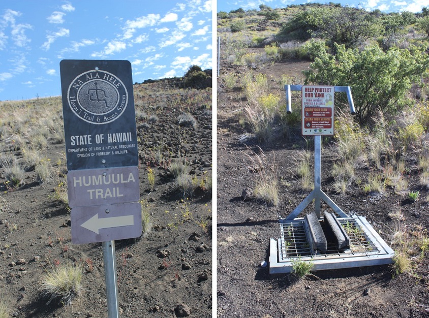
The trail actually starts about 1/10th of a mile up the road from the visitors center. I crossed the road and followed a 4WD trail to the left. The entire trail is located above treeline. It starts at 9200’, but since it’s actually a volcano very little grows on this mountain. I followed an old 4WD trail in the dark that led me to a station set up for me to clean off my shoes. I did so. This was the true start of the trail.
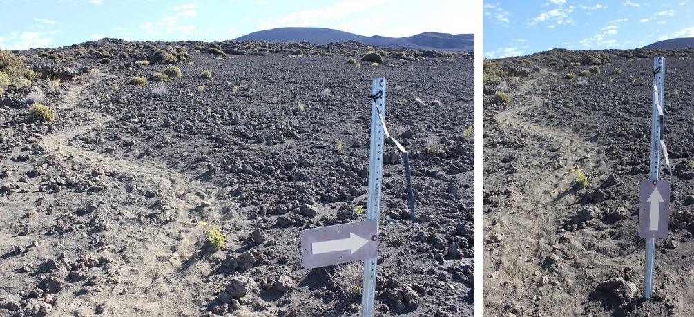
I looked for a trail register here as well but didn’t see one. I hiked about half a mile and came upon another sign. This one was broken and missing most of the information. Just imagine seeing this sign in the dark! I wasn’t sure which way to go, as both right and left seemed like legitimate trails. Actually, they were, but one went up the mountain and the other went back and connected with another road. I took the path to the left (which ended up being the correct path: I fixed the sign on my way down).
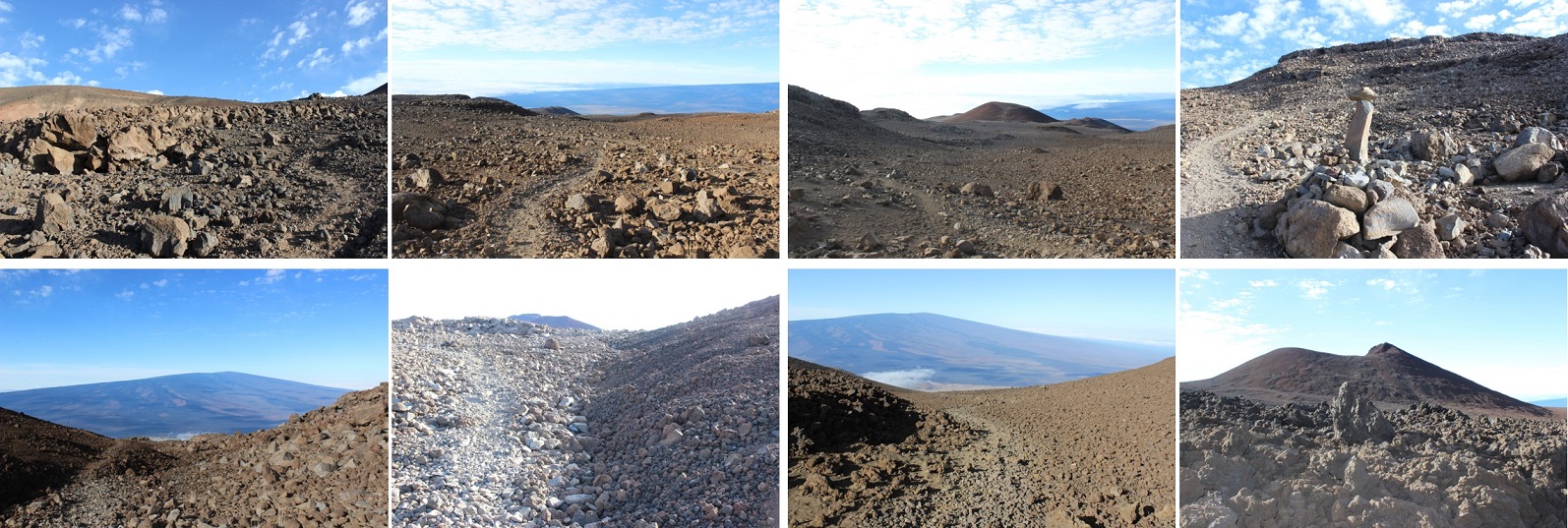
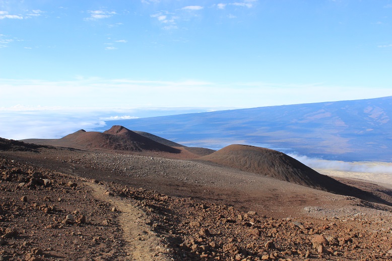
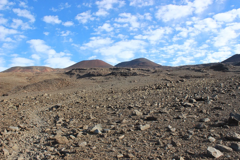
From this point on the trail passed through several different zones of lava, all with varying degrees of rock-like ground cover. It started out as a very sandy beach-like scree
And slowly changed into small rocks, and then medium sized rocks, and then large rocks. The terrain kept changing and changing as I hiked. It was difficult to stay on the trail, as in the dark everything looked the same. There was no clear trail visible in the sand and gravel. On the way back in the light of day however a trail was clearly visible.
There were posts in the ground every 100 yards or so, indicating the trail. The posts let me know I was on track, but varied in where they were placed: sometimes they were in front of the trail, sometimes behind, sometimes to the left or the right. But as long as I was near a post I knew I was in relatively close proximity to the actual trail.
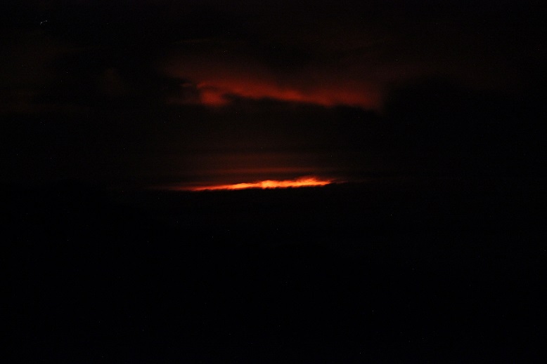
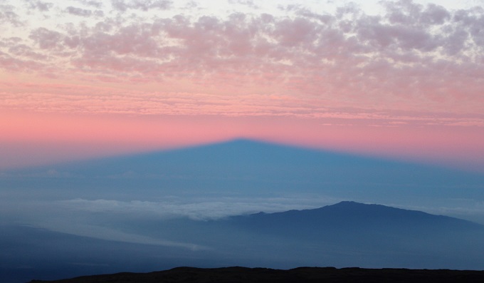
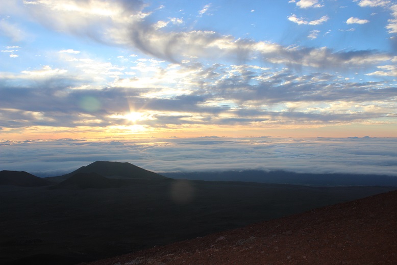
After hiking for about 2 miles I looked back and saw a glow in the distance. At first I thought I was looking at the town of Hilo, but that just didn’t make sense. Hilo should have been further north, and the lights reflecting off the low lying clouds looked more red than what should have been yellow street lights.
The further I hiked the more I kept stopping and looking behind me. Eventually it became clear I was looking at the glow of the volcanic eruption. Wow! What a sight to see! The horizon came into focus and I could see the red glow of the lava in the distance.
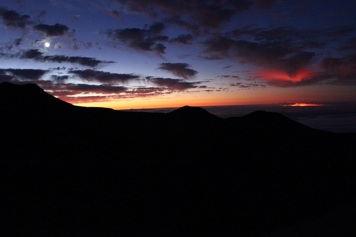
Did I mention it was cold? And windy! And really, really cold. And that wind!!! I’d brought my warm weather gear and North Face jacket with me on this trip, getting funny looks from employees at the Kona Airport as I wore it because it didn’t fit in my luggage. But I was praising myself for my foresight now. In fact, even with my snow gloves and knit hat I was shivering. I kept wanting to turn and look around at the lava glow but was too cold to stop and truly appreciate the view for any real length of time. My lips were frozen and my cheeks were numb. I wished it would warm up! I really didn’t like these sunrise summits: All this hiking in the dark and cold takes its toll on a hiker.
This hike seemed to go on and on and on with no clear gain in view. Everything looked the same in the dark: flat and still yet full of shadows. I was gaining in elevation, but it didn’t seem all that drastic. All I could think about as I trudged on was how wonderful it would be to have my family’s blessing and support on these hikes, instead of their constant fear and displeasure each time I go. I shouldn’t feel guilty every time I go on a hike. I’ve come to the realization I’m not going to change their views, so it’s something I’ll need to continue to enjoy for my own sake, and try my best to drown out their disappointment.
As the horizon started to lighten I saw the headlights from two cars come into view. There’s a paved road you can take to the summit (if you take a special tour and get a pass) that parallels the hiking trail for a bit. These groups must have been visitors on a sunrise tour.
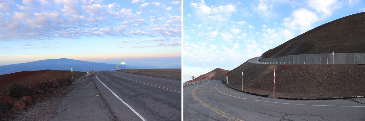
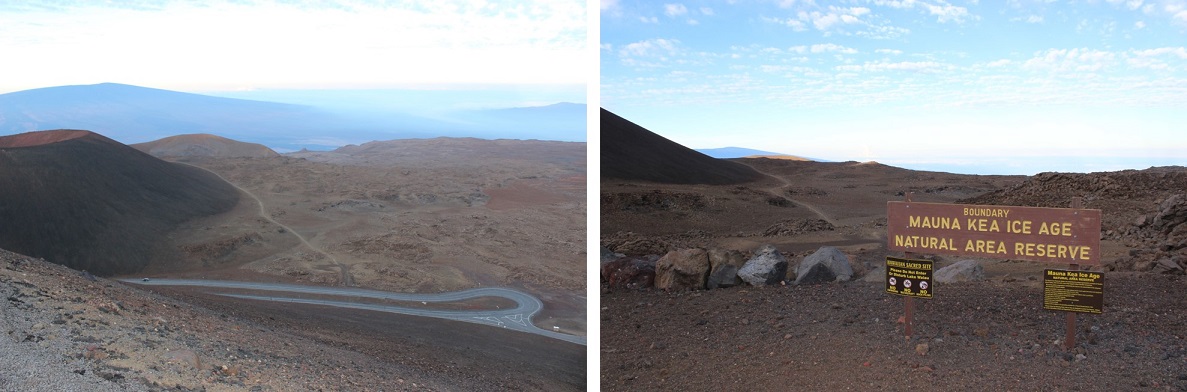
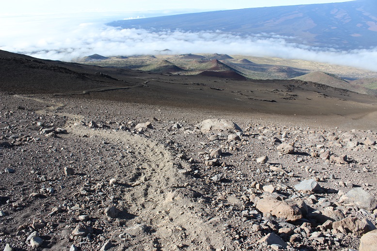
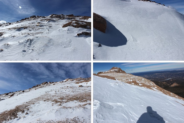
The end of the hike passes through the Mauna Kea Ice Age Natural Area Reserve, and then follows the paved road for the last mile to the summit.
This paved road also takes you to the Observatory.
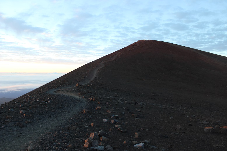
This was the easiest part of the hike by far: hiking on a paved road is much easier than hiking on uneven gravel. It was my goal to make it to the summit before the sunrise, and it looked like I was pushing it. The trail map said it was 6 miles to the summit, but it had obviously been longer than that, and my timing was off for a sunrise summit.
I looked to the left and could see a mountain in the morning light. This picture explains it all: the mountain in the middle is not a mountain at all, but the shadow of the volcano I was hiking, Mauna Kea, in the sunrise behind me.
The sun was rising so I quickened my pace and made it around the last curve. But it wasn’t the last of the hike. I still had a little ways to walk off the paved road to make it to the true summit. This was easy to navigate, only made difficult by the wind.
I summited at 5:30am, just as the sun was beginning to rise
There was a shrine at the summit. I respected the shrine by not standing on it or even touching it, even though it would have been extremely helpful in taking my summit photo.
This site has religious significance to the Hawaiian natives, including who’s allowed to stand on the summit so I tried to remain as respectful as possible.
At this point I was above the clouds, looking east towards the ocean.
It was very, very cold and the winds were probably around 40mph, much faster than the 5-10mph predicted. I was completely numb, and headed back down quickly. There were two couples on the paved road looking at the summit, dressed in parkas and huddling together to keep warm. They were respecting the ancient rules and weren’t summiting today (you must start hiking at the bottom to stand on the summit).
Here’s a good picture of where the trail starts back down at the junction of the paved road. If you look at the picture on the left, just as the trail ends it actually gives you the option of turning right and visiting an alpine lake.
This lake is named Lake Waiau, and sits at an elevation of 13,020’. This lake is also a sacred site. Waiau means “swirling water” in the Hawaiian language, and this phrase is probably meant to evoke the myth that Lake Waiau is the portal to the spirit world or underworld. In ancient times, the ali’i, Hawaiian royalty, would throw the umbilical cord of their first-born son into the lake to ensure their future success as a chief. When I visited the lake today I saw a shrine I expect was used for this purpose.
I turned around and descended through the varying degrees of decomposed lava. In the light of day the terrain looked like a moonscape, dry and barren with a large boulder thrown in here and there as if placed by an explosion.
There were several calderas in view, and I thought once again of how Mauna Kea usually erupts simultaneously with Kilauea. There had also been numerous earthquakes on Mauna Kea in the past few days, so I crossed my fingers I’d make it safely off the mountain before another earthquake occurred (side note: several occurred during our stay, with the largest registering 5.4: another eruption is eminent).
I turned around and looked back at the summit, in the light of day clearly being able to see the paved path to the top.
I stopped here to take a quick video of the landscape
The final descent took much longer than I remembered it taking to hike up. It was much steeper hiking back down than I’d remembered as well. I could see the marine layer coming in from Hilo and the rest of my path down to the visitor’s center. If you look closely here, you can see there isn’t a shadow being cast by the sun, but different colors of lava from separate eruptions flowing into one area.
I fixed the broken sign and made it back to the visitors center at 8:30am, making this 15.2 mile trek of 4500+ feet in elevation gain in 6 hours. The website information page says most fit hikers complete the hike in 8 hours. I was feeling pretty good about myself!
I came back here the next day for the stargazing, and talked with the rangers about their registration box. This was it, located as far from the parking lot as possible, adjacent to the front door around the back of the building. This doesn’t look like any hiker registration box I’ve ever seen, but for those of you intending to take this hike here’s what it looks like. It’s right below the “Beware of Invisible Cows” sign…
I’m glad I did everything possible to make this hike possible, even though my family wasn’t on board with the whole thing. It was truly worth the experience!
I woke up late this morning. My first alarm didn’t go off (the one set for 5 am so I could do yoga before my hike) but my second one did (the one set at 6:50am to wake up the kids). I jumped out of bed, scrambled to get ready, and was out the door in about 10 minutes, sans yoga for the morning.
I made it to the North Cheyenne Canyon Trailhead just before 8am. I met Dave there, and we started hiking around 8am, following Gold Camp Road until it intersected with the 624 St Mary’s Falls Trail. The trail was clear of mud and snow, and followed an ice filled creek filled with small trout (4-5 inches long).
There were several metal signs along the way which indicated the correct direction to hike, but as with most metal signs, the mileage was way off.
We went right at the cutoff for St Mary’s Falls and continued up the 624 and over a frozen creek. It looked slippery, but wasn’t dangerous enough to use spikes.
The trail winds up a ways, and eventually comes to a place where it looks like it ends, but it doesn’t. Just pass through the gateway and continue a few yards to come to service road 381. Take the road right (North) for another few yards and you’ll see cairns to the left that indicate the 672 or Nelsons Trail (Left/West).
Unfortunately, the 672 trail marker is difficult to find, and not on the road. It’s about 3 yards up from the road on the trail, hidden under a tree. The cairns make this an easy trail to find however.
At this point the trail became steeper, so Dave and I separated for a bit. As I was hiking I saw this cool heart shaped rock right in the middle of the trail.
And I could see the fire burning on Ft. Carson
This part of the hike just flew by! It was steep, but not too steep.
I love to hike inclines fast, and made it pretty quickly up to the top to enjoy the view of Almagre and Pikes Peak. And to sit for a while and have lunch.
The view was amazing, but it was incredibly windy!!!
From my lunch spot I could see the rest of our hike. That’s Mt. Rosa…
After about 20 minutes or so I was beginning to get really cold from sitting in one spot. My sweat had turned to ice and I was losing feeling in my fingers, so I got up and hiked a bit more to the 672/673 junction. The sign for the 673 had blown down, but still indicated which way to go.
I stood behind some trees, using them as a wind break, and waited for my hiking buddy. When he arrived we continued on the 673. We passed a very windy saddle, and then had 500 feet of elevation left to go before reaching the summit of Mt. Rosa. From almost the beginning of this part of the trail it was entirely covered in snow. It wasn’t enough snow/ice to put on microspikes, and we weren’t postholing too often, so our hiking boots did the trick. There was a pretty good trench indicating the way up.
The wind increased and I got colder and colder, but instead of my hiking too far ahead we stayed closer together for this last part of the hike.
Summit photo of Dave and I!
The views from the summit were amazing! We could see Almagre, Pikes Peak, Ft. Carson, the Penrose-Rosemont Reservoir, and a bunch of Mountain Ranges: The Wet Mountains, Spanish Peaks, Sangre de Cristos and Sawatch.
We didn’t stay long at the summit because that wind was INTENSE and cold! When we finally made it back to the Nelsons Trail area I began to thaw out a little. I could talk again and my fingers were burning, which meant the blood was rushing back into them. Dave was unfairly quite warm and tried to help warm up my hands. When we reached the frozen creek it had thawed out a little, giving us some traction as we crossed.
About halfway down towards St. Mary’s Falls I could take off my beanie and gloves, and the final part of the hike was pleasantly warm. It had just been cold near/above treeline because of the wind.
We made it back around 2:30pm, making the 12 mile, 4000’ in elevation gain trek in 6.5 hours.
I didn’t want to embarrass Thomas, but I really wanted to hike the incline with him and Troop 2, so we came up with a plan: I’d drive us both there, and while the group was getting ready to hike I’d take off first and meet everyone at the top. This way I didn’t embarrass the boys (who were slower hikers). It’s never fun to be shown up by a mom!
We got there at 7:55am for an 8am hike. It was CROWDED! I’ve never seen so many people there! It was a nice day, and 8am on a weekend, so I’m sure that added to the popularity. I usually hike the incline when it’s cold or very early in the morning on a Friday, so it isn’t very busy. I can only imagine the insanity in the summer!
It seemed like it took forever for Troop 2 to get ready: Everyone had to assemble, use the restroom, make sure paperwork was done, apply sunscreen, use the restroom again, etc. It was driving me mad, and eventually I said goodbye to Thomas and just started hiking.
My goal for today was not to stop: I could hike slow, but no stopping, just to see if I could make it to the top without stopping. About ¼ of the way up I heard trekking poles hitting the ground behind me. Those poles eventually started making me crazy, so I let the guy with the poles pass. He was from Norway, and thanked me for setting a great pace. His intended goal was Barr Camp, and maybe Pikes Peak today. He passed me for about 40 steps, and then I passed him again. I hate to play leapfrog with other hikers, but luckily he never passed me again and I stayed in the lead.
I was able to hike to the top of the incline without stopping! I made excellent time, and just a few minutes after I summited I was surprised to see Thomas making his way up as well!
He summited in 38 minutes! That’s a great time for his first time up the incline!
The hard part came next: waiting for the rest of the troop to make it. There was a lot of waiting! About 10 minutes after Thomas made it Max summited, and about 20 minutes after that two of the younger boys made it to the top. We waited almost 2 hours for the rest of the troop to summit. That’s long enough I could have hiked the 3 miles down and hiked back up the incline before they made it to the top! Oh well, I met a lot of fun people at the summit who were thrilled with their success (and tons of dogs too! For a “no dogs allowed” hike I counted over 10 of them).
After the entire troop made it to the top I took a Troop 2 picture of the excited boys.
Thomas and Max had been waiting over an hour and a half, so as soon as the picture was done they sprinted down the Barr Trail. I followed after them (a few minutes after, so they wouldn’t be bothered with me) and ran the entire way down as well. So that’s three firsts for me today: Hiking the incline without stopping, hiking the incline with Thomas, and running the entire length of the Barr Trail back down to the parking lot.
Today the weather was absolutely beautiful, but I had limited time (Cookie Booth at 2pm). I met up with Dave at the Red Rock Open Space North Lot for a hike through Red Rock Open Space and the Palmer Loop. I’ve hiked Red Rock Open space several times, usually sticking to the Quarry Trail. I knew it connected with Section 16 trails, but I wasn’t sure exactly how.
We started on the Mesa Trail, and took it to the Intenman / Section 16 trail connection. From there we followed the Palmer Loop for 5.5 miles, diverting only once to take the Waterfall Trail (out and back). The waterfall was completely frozen. I love frozen waterfalls!
The Loop eventually connected with Lower Gold Camp Road, which I found very interesting. I’ve been meaning to explore Gold Camp Road for some time now. We only hiked a small portion of the road, so I’ll need to come back to explore more. It’s fun how you can hike for miles and miles, only to end up on a road and near a parking lot, then get back on the trail to head back to the parking lot you originally parked in. I feel more familiar with the ‘other’ Red Rock Open Space and Section 16 trailheads.
Parts of the trail (those in the sun) were completely dry and warm, which made for lovely hiking. Other parts, however, were in canyons and covered in shade. Those areas were icy, slippery, and very cold. Beautiful though!
The final part of the trail took us on a hill with great views of Colorado Springs (and the landfill…)
I hiked part of the Heizer trail earlier this year when I was a bit rushed for time, so today I decided to hike it all the way to the Barr Trail.
I parked just outside of Cascade Park (the ONLY place you’re allowed to park to hike this trail).
And began by walking down the street and up the hill to the left. Once at the top of the driveway, the trail starts to the left.
I began at 7am. The trail conditions varied from completely clear, to covered in snow, to covered in ice. I never needed microspikes, but they would have come in handy crossing a couple of small streams (I had them but didn’t want to take the time to put them on: I just looked for a safer route and slipped a lot but never fell).
The trail had awesome signs indicating which trails were which. I LOVE these kinds of signs! There was no ambiguity: I could have hiked this route without a topo map.
I hiked up the Heizer Trail, over Cascade Mountain (9387’) and down to the Manitou Reservoir and Trail 638. This is where I lost about 2000’ in elevation (to be gained again on the way back). There were tons of signs letting me know I was in a watershed area and to hike off trail. From here I crossed French Creek and saw a rock painted like a fish. I’m assuming this part of the creek usually has more water…
Shortly after crossing French Creek I came to some amazing views of Pikes Peak! It’s wonderful how many different views this mountain offers!
The view never gets old!
From here signs indicated it was another 2.5 miles to Barr Trail, but it seemed much, much longer than that. I got in a lot of good thinking. After what seemed like forever I was deposited onto the Barr Trail. Here:
Immediately I thought: NO WAY!!! This CANNOT be where I’m supposed to end up? I thought I was supposed to connect close to Barr Camp, and I knew just by looking at where I was it was still miles away! I decided to hike up Barr Trail to the nearest mile marker sign. They’re placed every half mile, so the most I’d need to hike to get an accurate accounting of where I was was only half a mile. I hiked almost half a mile and saw this sign: MM5!!!
I didn’t really mentally calculate the distance I’d be hiking today, and it wasn’t until I hit this part of the Barr trail it hit me just how long this hike actually was. Hiking in from Heizer Trail added on 3 miles each way to Barr Camp… that meant this was an 18 mile round trip hike! Hmmm… Barr Camp was still almost 2 miles ahead of me. I looked at the time: I still had an hour before I had to turn back, so I had plenty of time, but when I looked up and saw those clouds moving in I knew I had to turn back: those were snow clouds, and forming rapidly.
I sighed inwardly: Oh well, I’ve been to Barr Camp over a dozen times. My main goal today was to find out where the Heizer trail connected with the Barr Trail, and I figured it out: at about MM4.5 I still had a minimum of 3 hours of hiking ahead of me, and needed to get a move on to stay ahead of that snow.
The hike back seemed shorter than the hike in, but it still went on forever, through the woods and over several mountains. Here’s a view of Pikes Peak on the way back:
The 2000’ in elevation gain on the way back didn’t hurt as much as I’d anticipated, and when I got to Cascade Mountain I saw something I hadn’t on the way in: A small piece of paper under a rock on a boulder. It was a Chinese Drawing. I left it there for whomever it was intended and began my hike down the Heizer Trail. That part of the hike seriously took forever! Those switchbacks never end!
About halfway down the mountain I saw a couple with a dog, headed to Hurricane Canyon. I’ll probably head there next, as it looks interesting! They were the only people I saw all day (besides a runner along the Barr Trail heading to Barr Camp).
I made it back to my truck at 1pm, just as the first snowflakes were beginning to fall. I’d made the right choice to turn back when I did! Soon it was a whiteout, but I was in my truck, so all was well.
So today I hiked 15 miles in 6 hours with 4300+ feet of elevation gain. Here’s a map of my route:
I know this trip report won’t sound like a big deal to most serious 14er hikers, but I have Raynaud’s, which means my body completely shuts down in the cold. My fingers and toes turn white, they lose function, and I can’t walk, talk or use my hands or feet. No, foot/hand warmers don’t work. Neither does layering. The fact I was able to complete a winter 14er, even an easy one in an easy year, was a huge accomplishment for me. Here’s the trip report:
Devil’s Playground – 13,070
Little Pikes Peak 13,363
Pikes Peak 14,115
Elevation Gain 4300’
RT 14 miles, 7.5 hours
Starting from Crags Campground
Brought microspikes but didn’t use them (I probably should have though). They will be useful in the next few days.
I’ve been trying to do this hike for months, but the weather forecast is always terrible in the winter at the top of Pikes Peak (today said 55mph wind gusts and -10* wind chill). However, last weekend I used a new jacket my mom got me, and while I was hiking I was actually hot and had to take it off, so I figured even though the weather was terrible it was a great chance to see what this jacket could do!
Also, I’d just picked up a pair of men’s work gloves (fleece) at Walmart for $6 that indicated they worked even in the worst of weather. I was seriously skeptical but willing to try anything: my fingers are always the first to lose function, and I can never get them warmed up again until I go back down in altitude (kind of like altitude sickness for my extremities).
My goal was to hike to Devil’s Playground, and possibly hike up Little Pikes Peak. I was thinking I’d check a couple of 13ers off my list (I know they aren’t ranked, etc.) I had no intention of hiking Pikes Peak today. I’ve hiked it 12 times (from Barr Trail) and had no need to do it again. I just wanted to see what this jacket and pair of gloves could do.
I used the Crags Trailhead. The gates were open but the 3 mile dirt road was covered in a layer of packed down snow.
I arrived at 6:45am and was the only one in the parking lot. The bathrooms were locked (presumably for winter) so I got my gear together and started at 7am. It was 21*.
The trail was very well marked (I love that!). It was also easy to follow, even with the snow. It looked like someone had tried to cross country ski in the area. I’m pretty sure it didn’t end well.
I took trail #664A for what seemed like forever before making it to treeline. I mean forever! The entire trail was covered in about 3-6 inches of packed snow (more in the drifts) and while I could hear the wind the trees blocked it from reaching me. It was slow going because the snow was a bit slippery and I had to watch each foot placement in the rocky areas. I had microspikes but didn’t use them because I didn’t think they’d make me any faster/more secure.
Here’s a photo of the trail as soon as you get above treeline: It’s straight up a mild, well maintained, snow covered drainage/gulley. This is where the temperature dropped and the wind picked up. It didn’t stop until I reached this point again on my way back down.
I continued hiking around some large rock formations and then areas of heavy snow.
The snow was beautiful, and had a sound. I’d say it sounded like glitter, but since that’s not possible I’ll instead say it sounded like very small chards of glass bouncing off the floor. But to me it had the sound of glitter.
I wasn’t cold yet, but I wasn’t at a high elevation either. I was at 11,500 feet. Eventually I got to the Pikes Peak Highway. I crossed the road and this is where the wind really picked up. I could see it blowing from the west, up and over the ridge.
It was phenomenal to watch! I could see the wind as it ascended the basin, and follow it as it blew up and over the ridge. I knew when to brace myself for impact, which was important because it knocked me over a few times.
A scarf was necessary. The only place I was cold was where my skin was exposed (woot! High five for the jacket and gloves!). I had to tuck my scarf into my jacket because the wind kept causing it to unravel. Wind was probably 25mph here.
Devil’s Playground was dry of snow except for when the wind blew… It was about 15* here (without wind).
The trail following the Pikes Peak Highway was easy to follow because of the snow drifts. I either avoided them or sank into them and trudged on. I was miserable due to the wind, but I was doing this!!! Still not cold!
The highway was completely devoid of snow, and curiously there was someone with a plow going up and down the road. They stopped twice to watch me, presumably because I was CRAZY to be out hiking in this WIND. I figured they weren’t taking any chances with icy roads either in all this wind. This also told me they were opening up the summit house today. Woot!
The pictures just don’t do this wind justice. It was intense and insane (and mostly invisible).
Here’s where the wind became intense for the first time. Gusts were about 55mph and sustained. I’d stand there for 30 seconds waiting for the ice intensity to pass. The wind made it cold, but not so cold I needed to stop.
Here’s a view of Pikes Peak (center) and Little Pikes Peak (right). Little Pikes Peak was the reason I was taking this hike. There’s no path to the summit, so I’d have to just find a route and follow it. Here’s where I made my first mistake.
I was coming from the North, and could only see one side of the mountain. I picked a route that looked hikeable and followed it. I stopped to breathe for a bit and take in my surroundings and realized I’d almost hiked to a place I couldn’t hike down from! The snow was heavy, and I’d have to say if there’s any avalanche danger (yes, I know it’s small) it’d be here. This snow was loose and I was in a precarious position, jumping from rock to rock: If I missed one I’d be sliding for quite a ways! I quickly hiked back the way I’d come and decided to scout out a better route up.
I found a much drier route to the south and made it to the summit of Little Pikes Peak after falling through and hitting just a few small boulders hidden in the snow (no big deal, I kind of expected this to happen). Here’s a summit selfie of me trying to smile (my lips were frozen). Moral of this story… summit Little Pikes Peak from the South! That side had snow, but no where near as much as the north side (I know, common sense…)
I sat on the summit and looked at Pikes Peak. It was much closer than I’d assumed. It couldn’t be much more than a mile or a mile and a half away. I was intrigued. For some reason I really wanted to summit from this route. I’ve summited 35 peaks solo, but Pikes was my first summit and I did it with a group and on another route. I kind of wanted to be able to say I’d summited this peak solo as well. And I’d never done a winter 14er (several winter 13ers, but no 14er in winter). The only problem was I could tell the toughest weather was ahead of me. I knew the temperature would drop as I ascended, and that wind blowing snow looked insane! I was already cold (but not as cold as I’d anticipated). I hate regrets, so I decided to go for it: I could always turn back if it got too difficult, right?
I stashed my trekking pole and began the final push to the summit. I was right, this was the most difficult part of the hike: The temperature dropped and the wind picked up. Here’s what it looks like just as the wind and snow hits you at -10* and 55mph…
Unfortunately, the wind didn’t come in gusts: it just kept coming. I’d brace myself, look for a cairn, note its position, put my head down and trudge towards it with the wind blasting me from the front. It was miserable and slow going but I had a plan. And while I should have been a popsicle in this weather I wasn’t! This was doable!
The cairns were extremely helpful since the route was covered in snow. I knew others must have hiked this trail in the past few days, but as I looked back at my tracks they were quickly covered by snow blown by wind just seconds after I’d passed. This meant I had to watch every step forward because I was kind of ‘breaking trail’ and didn’t know the best route. The rocks were slippery and again there were times I’d misjudge and my shin would get bruised from falling through snow and hitting rock. I thought about but didn’t use my microspikes yet again.
The wind didn’t stop, but as I gained the final pitch the ice and snow was taken out of the mix. This was a nice surprise! I summited at 11am. I still couldn’t feel my lips but was able to force an awkward smile for a summit selfie!
The summit was disappointingly dry for winter, but I’m pretty sure that’s normal for a summit (due to wind). Almost no one was there (3 cars in the parking lot?) so I walked across the parking lot and into the summit house. I briefly thought to myself it was cheating to go inside and get warm, but my water had frozen on the hike and I wanted a drink from the water fountain. The pipes had frozen in the summit house as well so I bought a Gatorade and immediately started feeling overheated. This was not good. It was way too hot in there and I was getting a headache. I had to get back down that mountain. I remarked to the cashier how I was shocked they were open today. Her reply told me she’s obviously had other plans besides work today and was surprised as well.
I met a group of three guys from Texas who’d driven to the top. They were impressed to hear I’d hiked up in this weather, and confused when I told them I was heading back down: “That’s the only way to get back to my truck”…
I bundled back up and headed outside. My path back down looked amazing.
The wind was constant during the hike back down, but the jacket and gloves had done their job: I still had full function of my fingers! Success!
The hike back down seemed much longer than the hike up. I kept thinking to myself it was crazy I’d hiked all this way straight up! I like elevation gain and tend to forget how much uphill I do on the way up until I’m on the way back down…
I marveled at the south side of Pikes Peak, and totally understand why they want to make this area into a ski area: It would totally work (if we forget about destroying tundra and wildlife).
Just before making it back to the trailhead I noticed prints that looked like bear tracks. They were obviously not fresh, but I was pretty sure that’s what I was seeing and they’d been created within the past few weeks or so. Hmmm… it seems someone woke up early and hopefully went back to bed. This doesn’t surprise me, due to our unseasonably warm winter and the fact I was hiking near a campground.
The last 3 miles of the hike I was roasting. I wanted to take off my jacket but was too stubborn to stop, so instead I took off my hat, gloves, and scarf while I was hiking and just carried the items. I was curiously pleased I was so warm in 30* weather I was taking off accessories. I made it back down at 2:30pm, making this a 7.5 hour hike. Slow for me, but I blame the wind…
All in all today’s adventure was a total success! The weather was brutal but having the right gear made all the difference. I wasn’t nearly as miserable as I’d anticipated I’d be. I learned a lot about my abilities, did a reality check on things I already knew but ‘forgot’, and can now say I’ve hiked a winter 14er! Woot!