RT Length: 10.5 miles
Elevation Gain: 4000’
I seriously debated on whether or not this hike would even be possible today: I had to be home no later than 2pm because that’s when Troop 2393 was meeting at my house for the Reach for the Peak survival competition. They train all year for this, and as their coach I didn’t want to disappoint them by making them late to the event. I did the math and figured if I started hiking at 1am I’d make it back just in time. It meant hiking and route finding for a long time in the dark, but I felt this was within my abilities.
I left my house at 10:00pm and drove to the trailhead. It took longer than anticipated on the 4WD part of the 390.2B dirt road due to running water (not a big deal) and mud puddles (looked bigger in the dark).

Parking was at the Lake Ann / Clear Creek / Huron / South Winfield 4WD trailhead. I didn’t make it to the trailhead until 1:15am, but I was on the trail by 1:30am. I set my alarm for 7am as a turnaround time. There’s plenty of parking at this trailhead.

The trail begins at the south end of the parking area, and follows the Lake Ann Trail

The beginning part of this trail is easy to follow on a wide path

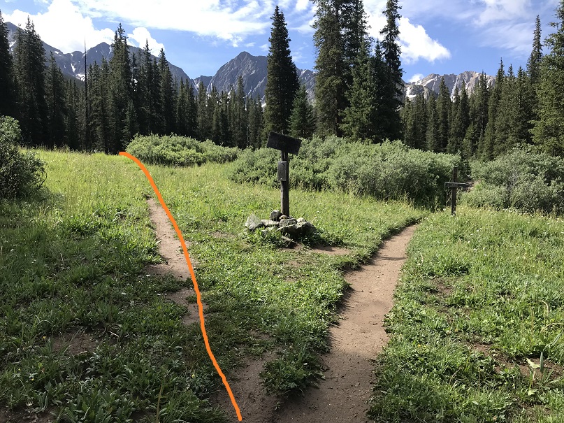
At this junction stay left

And enter the Collegiate Peaks Boundary at about .6 mi

If it had been daylight I would have been able to see North Apostle and Ice Mountain here

At 1.2 miles there’s another junction. Stay left here

I quickly arrived at the next (unmarked) junction and turned right, crossing a creek in the dark on a solid log bridge.

The trail was still easy to follow through the trees. I’d heard there was an avalanche area somewhere, but never saw it in the dark

The real route finding began when the trail ended at the creek

I spent about 15 minutes walking up and down the banks of the creek in the dark trying to find a way to cross, but was unable to find a log bridge (etc.). It looked like a bunch of logs and small trees had been used as a makeshift bridge recently, but it had washed out. I found a few trees, tried to make a quick bridge and realized I was just wasting time, so I took off my shoes and crossed the creek. There wasn’t a moon, but the stars tonight were amazing!
On my way back in the daylight I was able to find an actual crossing that didn’t require getting my feet wet. If you continue along the banks of the creek after the trail ends for about 200 feet you’ll find a large tree that creates a crossing. There’s some walking through the willows to find the crossing. Here’s where I found it:

After crossing the creek I sat down to put on my shoes and then continued southeast up and around to the basin. There was no trail here, so I just had to skirt the mountainside and head up. Also, I saw a flash of light and then it started to rain. Violently. There had only been a 20% chance of rain before noon today, and here it was at 3:30 in the morning pouring rain. I put on my helmet and sheltered in place until the lightening stopped. I was surprised the sky had been full of stars one minute, cloudy and stormy the next.
The rain stopped as quickly as it had started, but now everything was slippery and wet. This part of the hike required about a half mile of bushwhacking through the trees to make it to a waterfall area. There were several game and social trails, but none of them were continuous or led up to the waterfall area. I just kept hugging the mountainside, trekking southeast.

I made it out of the trees to a rocky waterfall area (that was more of a slope than a fall) and rock-hopped up


At the top of the waterfall area there are a bunch of willows and another stream to cross. The stream isn’t very wide, but it’s fast flowing and covered by willows. By getting creative and using the willows I was able to find a crossing area here

Once I crossed the creek I continued southeast into the basin. The only thing that made this difficult was route finding in the dark. I wasn’t able to see the outlines of the mountains, or anything much that was further than 20 feet ahead of me. I could hear rocks falling in the basin, and was glad I had already put on my helmet. I found a few cairns which were helpful to let me know I was on the right track. In the light of day I figured out this area is very well cairned, but in the dark I only saw about 1 out of every 5.

Here’s the route through the basin. I was doing this in the dark, so I just hugged the climbers left side of the basin (southeast)

I rock hopped on solid rocks and then came to a scree section. This scree section actually wasn’t that bad because of the earlier rain: scree provides great traction when wet. The wet rocks were another story: they were slippery and required patience.

I encountered two small patches of snow. I had crampons and microspikes, but after testing the snow didn’t feel they were necessary and just walked across them. I didn’t realize it in the dark, but I was aiming towards a rock ‘gate’. Also, I could hear running water to my left.

Once through the gate I turned left (east)

And gained the saddle between North Apostle and Ice Mountain

Once at the saddle I could summit either Ice Mountain or North Apostle, but chose North Apostle so I’d have a good view of Ice Mountain (class 3) on a class 2 route. Here’s the final push to North Apostle

This as an easy class 2 route that took me less than 15 minutes to complete from the saddle. The sun was beginning to rise

I summited at 6:15am

North Apostle
I turned and looked at the class 3 route up Ice Mountain. I knew I was a little pressed for time: my turnaround time was 7am, and it was already 6:15am. I didn’t stay long on North Apostle and worked my way carefully back towards the saddle, being careful not to slip on the wet rocks.

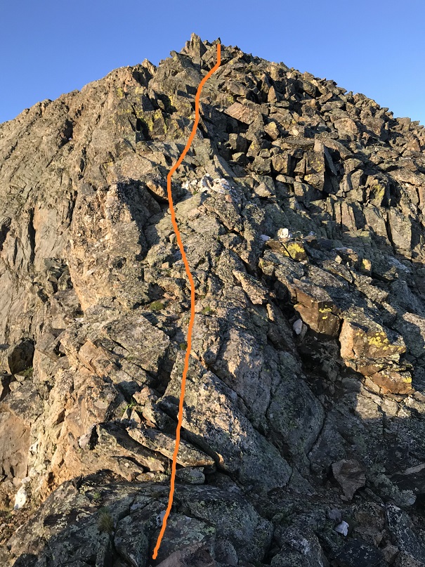
From the North Apostle/Ice Mountain Saddle the first obstacle was this section of climbing. I stuck to the ridge and didn’t find it difficult

I rounded the ridge and dipped down just a bit to a notch, crossed the notch, and headed up the solid and cairned route up the ridge. My alarm went off. Drat. It was 7am, and I was so close to the summit! I went back and forth in my head a few seconds, realized I’d started later than I’d planned, so surely I wasn’t at my halfway point yet? I could squeeze in another 20 minutes and still be fine, right? My math here was iffy, but I figured I was less than 15 minutes from the summit: I’d find a way to make up the time. Surely route finding would be much easier in the daylight? That would help… right?

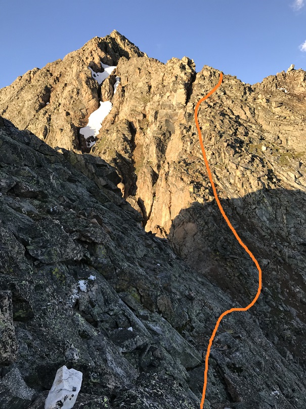
Here are some closer pictures

I came to a gully and took the solid route up and the dotted line down. The solid route felt sketchy to me (which is why I took the other way down). I don’t think either was better than the other.

I summited at 7:10am.

Ice Mountain
Here’s a look back on the route up to North Apostle

Ok, had no time to waste so I didn’t stay long at the summit. I decided to head down a slightly different way than I’d headed up.


Before making it to the saddle I found it easier to just begin descending a gully towards the gates I hadn’t seen in the dark

Here’s looking up at the way I came down from Ice Mountain

Ok, time to go through the gate and head back down the basin. This was so much easier in the daylight! I was definitely going to be able to make it back to my truck by 11am.

The running water I’d heard earlier was a trickle of a waterfall down the side of the mountain that was flowing beneath the rocks I was hopping.

I made it to the first patch of snow and misjudged its texture, thinking it would be similar to how it was when I crossed 2 hours ago: solid but soft enough to provide traction. I stepped on the snow and immediately slipped, flailing my arms and flying backwards, landing on my tailbone. That wasn’t snow but ice, and it was solid. It felt like I’d landed my tailbone on a rock. OUCH! I knew as soon as I hit this was not good. I jumped up, glad to find nothing was broken and I could stand, and did what I always do in this kind of a situation: I kept moving. The first fifty yards or so were painful, but then just became uncomfortable and it only hurt when I upclimbed. Eventually it stopped hurting altogether and just became a nuisance. I could tell it was going to bruise and it would be sore for a few weeks, but immediately walking it out seems to be the best policy for me.

All those cairns! I was so glad to see them all in the daylight! I rounded the end of the basin and had a great view of 14er Huron Peak as well as the rest of the route to the trail.

Route finding was much easier in the daylight on my way back down, but still an exercise in bushwhacking and following my compass. At least now I had visuals to help


The only problem with walking through all the grass and shrubs were they were still wet from the rain, and even though I have waterproof boots they were soaked through at this point. I was debating if it was even worth it to take off my boots for the creek crossing (decided in the end it was because stream water dries with a terrible stench) when I saw a felled tree crossing the creek. I crossed the creek on this tree and then walked through the willows a bit by the bank of the creek to eventually link back up with the trail. The rest of the hike out was uneventful and absolutely beautiful. I was able to enjoy the blue skies and greenery without the nuisance of mosquitoes. I saw a pair of hikers about 2 miles from the trailhead, but that was it for people for the whole day.
It had been my goal to make it back to my truck by 11am, and I was able to make it down by 10:40am, keeping me right on track to be home by 2pm so I could take a shower and pack before the girls all arrived. (For those wondering, they won the Eagle Award).
I made it back to my truck at 10:40am and went to stop my tracker, only to find it had stopped on its own 3.7 miles into the hike. I’m not sure why it stopped (maybe the rain?), but I don’t have a track for this climb, so I’m going by my iPhone app when I say it was about 10.5 miles and using the 4000’ in elevation gain as an approximate from topo maps and guide books. This hike took me just over 9 hours to complete.

I’m so taken in by not only Your trek to the summit but also what You go through to get there and back again.What a spectacular view You have presented to Your followers and Your future epitaph.Have always enjoyed Your photography and especially those photos of Yourself. Don’t know how You manage to scale the rocks You do in such a short time.You time Your alloted time so precise that I am awe struct by that alone.I really don’t know how You do what You do. What bothers me the most is when You fell and there is no one there to assist You in the time of a possible need.There is no doubt in my mind that You are one tough Dynamic Lady,but just the same it would be nice if someone were there to help You up and supply You with a pair of warm dry socks.Being a solo hiker,that probably won’t happen.But I can still hope that it will. One of the items that concerns me is Your loss of sleep because of all You do for Yourself and mostly for others. Thank You Miss Laura.
LikeLike